Bulancak geodata
Bulancak (Giresun) is a seat of a second-order administrative division; located in Turkey in Europe/Istanbul (GMT+3) time zone. With population of 43,635 people, there are 197 cities with bigger population in this country. Compared to other cities in Turkey, 87.2% of cities are located further ↓South; 62.7% of cities are located further ←West and 96.8% of cities have higher elevation than Bulancak. Note1


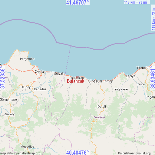
Bulancak GPS coordinates[2]
40° 56' 16.98" North, 38° 13' 53.328" East
| Map corner | latitude | longitude |
|---|---|---|
| Upper-left | 41.46707°, | 37.52836° |
| Center: | 40.93805°, | 38.23148° |
| Lower-right: | 40.40476°, | 38.93461° |
| Map W x H: | 118.1×118.1 km | = 73.4×73.4mi |
| max Lat: | 42.02683° ⇑12.8% North |
| Bulancak: | 40.93805° |
| min Lat: | ⇓87.2% South 35.9025° |
| min Long | Bulancak | max Long |
| 25.90902° | 38.23148° | 44.60099° |
| W 62.7%⇐ | ⇒37.3% E |
Elevation
Elevation of Bulancak is 12 m = 39 ft, and this is 705.4 m = 2314 ft below average elevation for this country.
| Max E: |
2682 m = 8799 ft | 96.8% |
| Avg. | 717.4 m = 2354 ft | |
| Bulancak | 12 m = 39 ft | |
Min E: |
0 m = 0 ft | 3.2% |
See also: Bulancak elevation on elevation.city.
Geographical zone
Bulancak is located in North temperate zone (between Tropic of Cancer and the Arctic Circle). Distance of this Northern Tropic circle is 1946 km =1209.2 mi to South.| Distance of | km | miles | from Bulancak |
|---|---|---|---|
| North Pole | 5455.2 | 3389.7 | to North |
| Arctic Circle | 2849.3 | 1770.5 | to North |
| Tropic Cancer | 1946 | 1209.2 | to South |
| Equator | 4551.9 | 2828.4 | to South |


Nearby cities:
15 places around Bulancak: (largest is in red/bold)
• Altınordu
30.5 km =19 mi,  279°
279°
• Dereli
28.4 km =17.6 mi,  141°
141°
• Espiye
39.6 km =24.6 mi,  88°
88°
• Giresun
13.3 km =8.3 mi,  100°
100°
• Gülyalı
15.5 km =9.6 mi, 279°
• Kabadüz
30.4 km =18.9 mi,  253°
253°
• Karabulduk
29.8 km =18.5 mi,  116°
116°
• Keşap
22.9 km =14.2 mi, 97°
• Kovanlık
22.7 km =14.1 mi,  206°
206°
• Ordu
29 km =18 mi, 278°
• Piraziz
9.1 km =5.7 mi,  259°
259°
• Piraziz
10.4 km =6.5 mi, 279°
• Uzunisa
32.3 km =20.1 mi,  265°
265°
• Yavuzkemal
28.6 km =17.8 mi,  161°
161°
• Yağlıdere
33.9 km =21.1 mi,  105°
105°
Sources, notices
• [Note1] Compared only with cities in Turkey existing in our database
• [Src1] Map data: © OpenStreetMap contributors (CC-BY-SA)
• [Src2] Other city data from geonames.org with taken over terms of usage.
• [Src3] Geographical zone / Annual Mean Temperature by Robert A. Rohde @ Wikipedia
