Üsküdar geodata
Üsküdar (Istanbul) is a populated place; located in Turkey in Europe/Istanbul (GMT+3) time zone. With population of 582,666 people, there are 12 cities with bigger population in this country. Compared to other cities in Turkey, 90% of cities are located further ↓South; 83.9% of cities are located further →East and 91.8% of cities have higher elevation than Üsküdar. Note1


Üsküdar GPS coordinates[2]
41° 1' 21.864" North, 29° 0' 49.176" East
| Map corner | latitude | longitude |
|---|---|---|
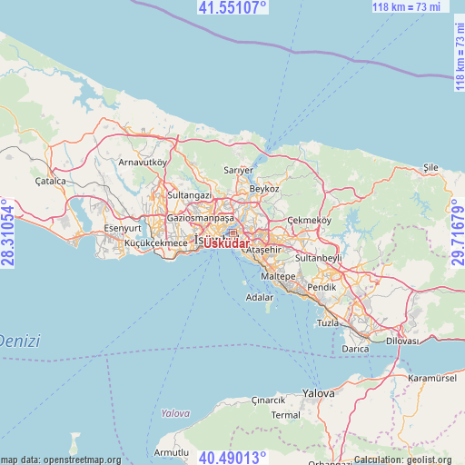
| Upper-left | 41.55107°, | 28.31054° |
| Center: | 41.02274°, | 29.01366° |
| Lower-right: | 40.49013°, | 29.71679° |
| Map W x H: | 118×118 km | = 73.3×73.3mi |
| max Lat: | 42.02683° ⇑10% North |
| Üsküdar: | 41.02274° |
| min Lat: | ⇓90% South 35.9025° |
| min Long | Üsküdar | max Long |
| 25.90902° | 29.01366° | 44.60099° |
| W 16.1%⇐ | ⇒83.9% E |
Elevation
Elevation of Üsküdar is 30 m = 98 ft, and this is 687.4 m = 2255 ft below average elevation for this country.
| Max E: |
2682 m = 8799 ft | 91.8% |
| Avg. | 717.4 m = 2354 ft | |
| Üsküdar | 30 m = 98 ft | |
Min E: |
0 m = 0 ft | 8.2% |
See also: Üsküdar elevation on elevation.city.
Geographical zone
Üsküdar is located in North temperate zone (between Tropic of Cancer and the Arctic Circle). Distance of this Northern Tropic circle is 1955.4 km =1215 mi to South.| Distance of | km | miles | from Üsküdar |
|---|---|---|---|
| North Pole | 5445.8 | 3383.9 | to North |
| Arctic Circle | 2839.9 | 1764.6 | to North |
| Tropic Cancer | 1955.4 | 1215 | to South |
| Equator | 4561.3 | 2834.3 | to South |


Nearby cities:
15 places around Üsküdar: (largest is in red/bold)
• Ataşehir
9.7 km =6 mi,  116°
116°
• Bahçelievler
13.1 km =8.1 mi,  260°
260°
• Bağcılar
13.3 km =8.3 mi,  277°
277°
• Eminönü
3.3 km =2.1 mi, 260°
• Esenler
11.8 km =7.3 mi, 281°
• Istanbul
5.5 km =3.4 mi, 259°
• Kınalı
13.3 km =8.3 mi,  164°
164°
• Maltepe
15.3 km =9.5 mi,  129°
129°
• Merter Keresteciler
10.8 km =6.7 mi, 264°
• Umraniye
9.3 km =5.8 mi,  94°
94°
• Zeytinburnu
9.7 km =6 mi,  251°
251°
• güngören merter
10.7 km =6.6 mi, 260°
• Çekmeköy
14 km =8.7 mi,  81°
81°
• Ümraniye
7.4 km =4.6 mi, 81°
• Şişli
4.7 km =2.9 mi,  332°
332°
Sources, notices
• [Note1] Compared only with cities in Turkey existing in our database
• [Src1] Map data: © OpenStreetMap contributors (CC-BY-SA)
• [Src2] Other city data from geonames.org with taken over terms of usage.
• [Src3] Geographical zone / Annual Mean Temperature by Robert A. Rohde @ Wikipedia
