Bağcılar geodata
Bağcılar (Istanbul) is a populated place; located in Turkey in Europe/Istanbul (GMT+3) time zone. With population of 724,270 people, there are 9 cities with bigger population in this country. Compared to other cities in Turkey, 90.6% of cities are located further ↓South; 85.1% of cities are located further →East and 81.2% of cities have higher elevation than Bağcılar. Note1


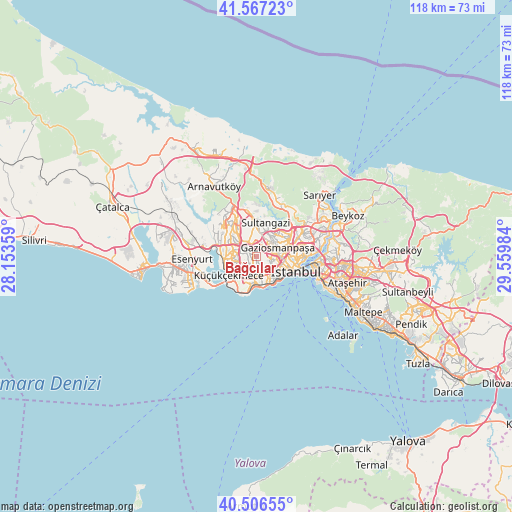
Bağcılar GPS coordinates[2]
41° 2' 20.508" North, 28° 51' 24.156" East
| Map corner | latitude | longitude |
|---|---|---|
| Upper-left | 41.56723°, | 28.15359° |
| Center: | 41.03903°, | 28.85671° |
| Lower-right: | 40.50655°, | 29.55984° |
| Map W x H: | 117.9×117.9 km | = 73.3×73.3mi |
| max Lat: | 42.02683° ⇑9.4% North |
| Bağcılar: | 41.03903° |
| min Lat: | ⇓90.6% South 35.9025° |
| min Long | Bağcılar | max Long |
| 25.90902° | 28.85671° | 44.60099° |
| W 14.9%⇐ | ⇒85.1% E |
Elevation
Elevation of Bağcılar is 105 m = 344 ft, and this is 612.4 m = 2009 ft below average elevation for this country.
| Max E: |
2682 m = 8799 ft | 81.2% |
| Avg. | 717.4 m = 2354 ft | |
| Bağcılar | 105 m = 344 ft | |
Min E: |
0 m = 0 ft | 18.8% |
See also: Bağcılar elevation on elevation.city.
Geographical zone
Bağcılar is located in North temperate zone (between Tropic of Cancer and the Arctic Circle). Distance of this Northern Tropic circle is 1957.2 km =1216.1 mi to South.| Distance of | km | miles | from Bağcılar |
|---|---|---|---|
| North Pole | 5443.9 | 3382.7 | to North |
| Arctic Circle | 2838.1 | 1763.5 | to North |
| Tropic Cancer | 1957.2 | 1216.1 | to South |
| Equator | 4563.1 | 2835.4 | to South |


Nearby cities:
15 places around Bağcılar: (largest is in red/bold)
• Bahçelievler
4.1 km =2.5 mi,  176°
176°
• Başakşehir
7.6 km =4.7 mi,  322°
322°
• Eminönü
10.2 km =6.3 mi,  103°
103°
• Esenler
1.7 km =1.1 mi,  73°
73°
• Esenyurt
15.1 km =9.4 mi,  264°
264°
• Istanbul
8.3 km =5.2 mi,  109°
109°
• Kemerburgaz
14.2 km =8.8 mi,  20°
20°
• Mahmutbey
3.1 km =1.9 mi,  301°
301°
• Merter Keresteciler
3.8 km =2.4 mi,  139°
139°
• Sultangazi
7.6 km =4.7 mi,  7°
7°
• Yakuplu
16.2 km =10.1 mi,  249°
249°
• Zeytinburnu
6.4 km =4 mi, 141°
• güngören merter
4.4 km =2.7 mi, 143°
• Üsküdar
13.3 km =8.3 mi, 97°
• Şişli
11.2 km =7 mi,  77°
77°
Sources, notices
• [Note1] Compared only with cities in Turkey existing in our database
• [Src1] Map data: © OpenStreetMap contributors (CC-BY-SA)
• [Src2] Other city data from geonames.org with taken over terms of usage.
• [Src3] Geographical zone / Annual Mean Temperature by Robert A. Rohde @ Wikipedia
