Doğançay geodata
Doğançay (Sakarya) is a seat of a third-order administrative division; located in Turkey in Europe/Istanbul (GMT+3) time zone. In our database, there are 1323 cities with bigger population. Compared to other cities in Turkey, 79.5% of cities are located further ↓South; 73.9% of cities are located further →East and 86.2% of cities have higher elevation than Doğançay. Note1


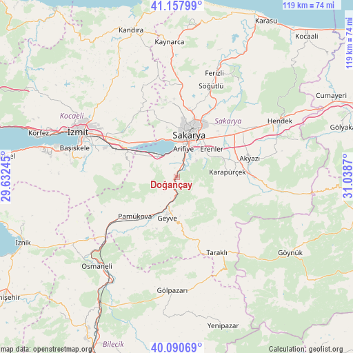
Doğançay GPS coordinates[2]
40° 37' 35.292" North, 30° 20' 8.052" East
| Map corner | latitude | longitude |
|---|---|---|
| Upper-left | 41.15799°, | 29.63245° |
| Center: | 40.62647°, | 30.33557° |
| Lower-right: | 40.09069°, | 31.0387° |
| Map W x H: | 118.7×118.7 km | = 73.8×73.8mi |
| max Lat: | 42.02683° ⇑20.5% North |
| Doğançay: | 40.62647° |
| min Lat: | ⇓79.5% South 35.9025° |
| min Long | Doğançay | max Long |
| 25.90902° | 30.33557° | 44.60099° |
| W 26.1%⇐ | ⇒73.9% E |
Elevation
Elevation of Doğançay is 64 m = 210 ft, and this is 653.4 m = 2144 ft below average elevation for this country.
| Max E: |
2682 m = 8799 ft | 86.2% |
| Avg. | 717.4 m = 2354 ft | |
| Doğançay | 64 m = 210 ft | |
Min E: |
0 m = 0 ft | 13.8% |
See also: Turkey elevation on elevation.city.
Geographical zone
Doğançay is located in North temperate zone (between Tropic of Cancer and the Arctic Circle). Distance of this Northern Tropic circle is 1911.3 km =1187.6 mi to South.| Distance of | km | miles | from Doğançay |
|---|---|---|---|
| North Pole | 5489.8 | 3411.2 | to North |
| Arctic Circle | 2883.9 | 1792 | to North |
| Tropic Cancer | 1911.3 | 1187.6 | to South |
| Equator | 4517.2 | 2806.9 | to South |


Nearby cities:
15 places around Doğançay: (largest is in red/bold)
• Adapazarı
18.1 km =11.2 mi,  18°
18°
• Akmeşe
27.3 km =17 mi,  334°
334°
• Akyazı
25 km =15.5 mi,  74°
74°
• Arifiye
8.3 km =5.2 mi,  8°
8°
• Büyükderbent
20.7 km =12.9 mi,  295°
295°
• Erenler
15.1 km =9.4 mi, 18°
• Geyve
13.7 km =8.5 mi,  195°
195°
• Karapürçek
17.3 km =10.7 mi,  84°
84°
• Kazımpaşa
18.7 km =11.6 mi,  349°
349°
• Kullar
31.1 km =19.3 mi,  290°
290°
• Köseköy
30.6 km =19 mi, 294°
• Pamukova
19.4 km =12.1 mi,  227°
227°
• Sapanca
9.2 km =5.7 mi,  321°
321°
• Serdivan
16.8 km =10.4 mi, 12°
• Taraklı
28.8 km =17.9 mi,  152°
152°
Sources, notices
• [Note1] Compared only with cities in Turkey existing in our database
• [Src1] Map data: © OpenStreetMap contributors (CC-BY-SA)
• [Src2] Other city data from geonames.org with taken over terms of usage.
• [Src3] Geographical zone / Annual Mean Temperature by Robert A. Rohde @ Wikipedia
