Pamukova geodata
Pamukova (Sakarya) is a seat of a second-order administrative division; located in Turkey in Europe/Istanbul (GMT+3) time zone. With population of 14,885 people, there are 392 cities with bigger population in this country. Compared to other cities in Turkey, 77.7% of cities are located further ↓South; 74.9% of cities are located further →East and 81% of cities have higher elevation than Pamukova. Note1


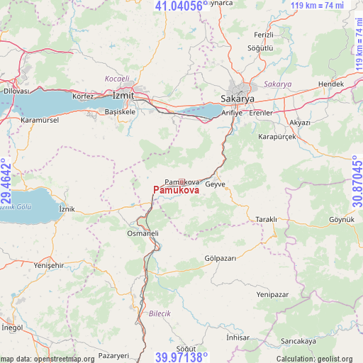
Pamukova GPS coordinates[2]
40° 30' 29.16" North, 30° 10' 2.352" East
| Map corner | latitude | longitude |
|---|---|---|
| Upper-left | 41.04056°, | 29.4642° |
| Center: | 40.5081°, | 30.16732° |
| Lower-right: | 39.97138°, | 30.87045° |
| Map W x H: | 118.9×118.9 km | = 73.9×73.9mi |
| max Lat: | 42.02683° ⇑22.3% North |
| Pamukova: | 40.5081° |
| min Lat: | ⇓77.7% South 35.9025° |
| min Long | Pamukova | max Long |
| 25.90902° | 30.16732° | 44.60099° |
| W 25.1%⇐ | ⇒74.9% E |
Elevation
Elevation of Pamukova is 106 m = 348 ft, and this is 611.4 m = 2006 ft below average elevation for this country.
| Max E: |
2682 m = 8799 ft | 81% |
| Avg. | 717.4 m = 2354 ft | |
| Pamukova | 106 m = 348 ft | |
Min E: |
0 m = 0 ft | 19% |
See also: Turkey elevation on elevation.city.
Geographical zone
Pamukova is located in North temperate zone (between Tropic of Cancer and the Arctic Circle). Distance of this Northern Tropic circle is 1898.2 km =1179.5 mi to South.| Distance of | km | miles | from Pamukova |
|---|---|---|---|
| North Pole | 5503 | 3419.4 | to North |
| Arctic Circle | 2897.1 | 1800.2 | to North |
| Tropic Cancer | 1898.2 | 1179.5 | to South |
| Equator | 4504.1 | 2798.7 | to South |


Nearby cities:
15 places around Pamukova: (largest is in red/bold)
• Arifiye
26.4 km =16.4 mi,  35°
35°
• Bahçecik
27.8 km =17.3 mi,  309°
309°
• Büyükderbent
22.6 km =14 mi,  348°
348°
• Doğançay
19.4 km =12.1 mi,  47°
47°
• Elmalı
24.2 km =15 mi,  271°
271°
• Geyve
10.6 km =6.6 mi,  90°
90°
• Gölpazarı
27.9 km =17.3 mi,  152°
152°
• Karşıyaka
28.1 km =17.5 mi,  317°
317°
• Kullar
28.3 km =17.6 mi,  327°
327°
• Köseköy
29.2 km =18.1 mi, 332°
• Nüzhetiye
29.6 km =18.4 mi,  299°
299°
• Osmaneli
21.2 km =13.2 mi,  217°
217°
• Sansarak
28.7 km =17.8 mi, 265°
• Sapanca
22.1 km =13.7 mi,  22°
22°
• Yuvacık
26.2 km =16.3 mi, 319°
Sources, notices
• [Note1] Compared only with cities in Turkey existing in our database
• [Src1] Map data: © OpenStreetMap contributors (CC-BY-SA)
• [Src2] Other city data from geonames.org with taken over terms of usage.
• [Src3] Geographical zone / Annual Mean Temperature by Robert A. Rohde @ Wikipedia
