Geyve geodata
Geyve (Sakarya) is a seat of a second-order administrative division; located in Turkey in Europe/Istanbul (GMT+3) time zone. With population of 20,199 people, there are 327 cities with bigger population in this country. Compared to other cities in Turkey, 77.6% of cities are located further ↓South; 74.2% of cities are located further →East and 83.3% of cities have higher elevation than Geyve. Note1


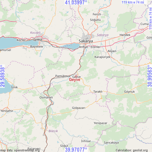
Geyve GPS coordinates[2]
40° 30' 27" North, 30° 17' 33" East
| Map corner | latitude | longitude |
|---|---|---|
| Upper-left | 41.03997°, | 29.58938° |
| Center: | 40.5075°, | 30.2925° |
| Lower-right: | 39.97077°, | 30.99563° |
| Map W x H: | 118.9×118.9 km | = 73.9×73.9mi |
| max Lat: | 42.02683° ⇑22.4% North |
| Geyve: | 40.5075° |
| min Lat: | ⇓77.6% South 35.9025° |
| min Long | Geyve | max Long |
| 25.90902° | 30.2925° | 44.60099° |
| W 25.8%⇐ | ⇒74.2% E |
Elevation
Elevation of Geyve is 84 m = 276 ft, and this is 633.4 m = 2078 ft below average elevation for this country.
| Max E: |
2682 m = 8799 ft | 83.3% |
| Avg. | 717.4 m = 2354 ft | |
| Geyve | 84 m = 276 ft | |
Min E: |
0 m = 0 ft | 16.7% |
See also: Turkey elevation on elevation.city.
Geographical zone
Geyve is located in North temperate zone (between Tropic of Cancer and the Arctic Circle). Distance of this Northern Tropic circle is 1898.1 km =1179.4 mi to South.| Distance of | km | miles | from Geyve |
|---|---|---|---|
| North Pole | 5503.1 | 3419.5 | to North |
| Arctic Circle | 2897.2 | 1800.2 | to North |
| Tropic Cancer | 1898.1 | 1179.4 | to South |
| Equator | 4504 | 2798.7 | to South |


Nearby cities:
15 places around Geyve: (largest is in red/bold)
• Adapazarı
31.8 km =19.8 mi,  17°
17°
• Akyazı
34.1 km =21.2 mi,  54°
54°
• Arifiye
22 km =13.7 mi,  12°
12°
• Büyükderbent
26.8 km =16.7 mi,  325°
325°
• Doğançay
13.7 km =8.5 mi, 15°
• Erenler
28.8 km =17.9 mi, 17°
• Gölpazarı
24.9 km =15.5 mi,  175°
175°
• Karapürçek
25.7 km =16 mi, 54°
• Kazımpaşa
31.6 km =19.6 mi,  0°
0°
• Osmaneli
28.9 km =18 mi,  234°
234°
• Pamukova
10.6 km =6.6 mi,  270°
270°
• Sapanca
20.6 km =12.8 mi,  354°
354°
• Serdivan
30.5 km =19 mi, 14°
• Taraklı
20.9 km =13 mi,  125°
125°
• Yuvacık
34 km =21.1 mi,  306°
306°
Sources, notices
• [Note1] Compared only with cities in Turkey existing in our database
• [Src1] Map data: © OpenStreetMap contributors (CC-BY-SA)
• [Src2] Other city data from geonames.org with taken over terms of usage.
• [Src3] Geographical zone / Annual Mean Temperature by Robert A. Rohde @ Wikipedia
