Port of Spain geodata
Port of Spain is a capital of a political entity; located in Trinidad and Tobago in America/Port_of_Spain (GMT-4) time zone. With population of 49,031 people, there are 3 cities with bigger population in this country. Compared to other cities in Trinidad and Tobago, 86.4% of cities are located further ↓South; 81.8% of cities are located further →East and 59.1% of cities have higher elevation than Port of Spain. Note1


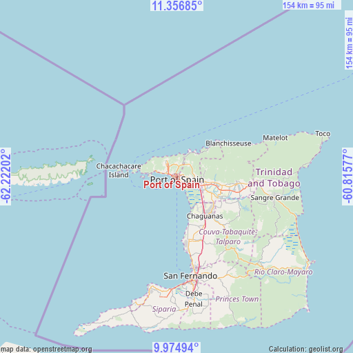
Port of Spain GPS coordinates[2]
10° 40' 0.048" North, 61° 31' 8.004" West
| Map corner | latitude | longitude |
|---|---|---|
| Upper-left | 11.35685°, | -62.22202° |
| Center: | 10.66668°, | -61.51889° |
| Lower-right: | 9.97494°, | -60.81577° |
| Map W x H: | 153.7×153.7 km | = 95.5×95.5mi |
| max Lat: | 11.18229° ⇑13.6% North |
| Port of Spain: | 10.66668° |
| min Lat: | ⇓86.4% South 10.14525° |
| min Long | Port of Spain | max Long |
| -61.68407° | -61.51889° | -60.73525° |
| W 18.2%⇐ | ⇒81.8% E |
Elevation
Elevation of Port of Spain is 21 m = 69 ft, and this is 15.9 m = 52 ft below average elevation for this country.
| Max E: |
100 m = 328 ft | 59.1% |
| Avg. | 36.9 m = 121 ft | |
| Port of Spain | 21 m = 69 ft | |
Min E: |
3 m = 10 ft | 40.9% |
See also: Port of Spain elevation on elevation.city.
Geographical zone
Port of Spain is located in North Torrid zone (between Equator and Tropic of Cancer). Distance of Equator is 1186 km =736.9 mi to South.| Distance of | km | miles | from Port of Spain |
|---|---|---|---|
| North Pole | 8821 | 5481.1 | to North |
| Arctic Circle | 6215.2 | 3861.9 | to North |
| Tropic Cancer | 1419.9 | 882.3 | to North |
| Equator | 1186 | 736.9 | to South |


Nearby cities:
15 places around Port of Spain: (largest is in red/bold)
• Arima
26.1 km =16.2 mi,  97°
97°
• Arouca
20.5 km =12.7 mi, 101°
• Chaguanas
20.1 km =12.5 mi,  146°
146°
• Couva
27.7 km =17.2 mi,  168°
168°
• Diego Martin
7.9 km =4.9 mi,  319°
319°
• Laventille
2.9 km =1.8 mi,  131°
131°
• Marabella
40.9 km =25.4 mi, 168°
• Mon Repos
43.8 km =27.2 mi, 169°
• Mucurapo
2 km =1.2 mi,  256°
256°
• Paradise
17.1 km =10.6 mi, 95°
• Petit Valley
4.8 km =3 mi, 319°
• San Fernando
43.4 km =27 mi, 172°
• Sangre Grande
43.4 km =27 mi, 101°
• Tabaquite
39.3 km =24.4 mi,  141°
141°
• Tunapuna
14.3 km =8.9 mi, 96°
In other languages:
- In Spanish: Puerto España
- In France: Port-d'Espagne
- In German: Port-of-Spain
- In Russian: Порт-оф-Спейн
- In Chinese: 西班牙港
Sources, notices
• [Note1] Compared only with cities in Trinidad and Tobago existing in our database
• [Src1] Map data: © OpenStreetMap contributors (CC-BY-SA)
• [Src2] Other city data from geonames.org with taken over terms of usage.
• [Src3] Geographical zone / Annual Mean Temperature by Robert A. Rohde @ Wikipedia
