Mucurapo geodata
Mucurapo (Port of Spain) is a populated place; located in Trinidad and Tobago in America/Port_of_Spain (GMT-4) time zone. With population of 4,342 people, there are 19 cities with bigger population in this country. Compared to other cities in Trinidad and Tobago, 81.8% of cities are located further ↓South; 86.4% of cities are located further →East and 100% of cities have higher elevation than Mucurapo. Note1


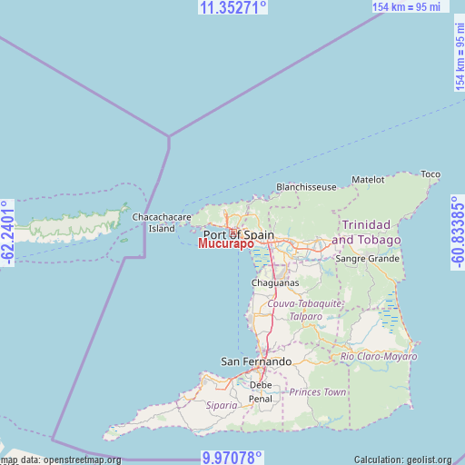
Mucurapo GPS coordinates[2]
10° 39' 45.108" North, 61° 32' 13.092" West
| Map corner | latitude | longitude |
|---|---|---|
| Upper-left | 11.35271°, | -62.2401° |
| Center: | 10.66253°, | -61.53697° |
| Lower-right: | 9.97078°, | -60.83385° |
| Map W x H: | 153.7×153.7 km | = 95.5×95.5mi |
| max Lat: | 11.18229° ⇑18.2% North |
| Mucurapo: | 10.66253° |
| min Lat: | ⇓81.8% South 10.14525° |
| min Long | Mucurapo | max Long |
| -61.68407° | -61.53697° | -60.73525° |
| W 13.6%⇐ | ⇒86.4% E |
Elevation
Elevation of Mucurapo is 3 m = 10 ft, and this is 33.9 m = 111 ft below average elevation for this country.
| Max E: |
100 m = 328 ft | 100% |
| Avg. | 36.9 m = 121 ft | |
| Mucurapo | 3 m = 10 ft | |
Min E: |
3 m = 10 ft | 0% |
See also: Trinidad and Tobago elevation on elevation.city.
Geographical zone
Mucurapo is located in North Torrid zone (between Equator and Tropic of Cancer). Distance of Equator is 1185.6 km =736.7 mi to South.| Distance of | km | miles | from Mucurapo |
|---|---|---|---|
| North Pole | 8821.5 | 5481.4 | to North |
| Arctic Circle | 6215.6 | 3862.2 | to North |
| Tropic Cancer | 1420.4 | 882.6 | to North |
| Equator | 1185.6 | 736.7 | to South |


Nearby cities:
15 places around Mucurapo: (largest is in red/bold)
• Arima
28 km =17.4 mi,  95°
95°
• Arouca
22.4 km =13.9 mi, 99°
• Chaguanas
20.9 km =13 mi,  140°
140°
• Couva
27.8 km =17.3 mi,  164°
164°
• Diego Martin
7.2 km =4.5 mi,  333°
333°
• Laventille
4.4 km =2.7 mi,  109°
109°
• Marabella
40.8 km =25.4 mi,  166°
166°
• Mon Repos
43.7 km =27.2 mi, 166°
• Paradise
19 km =11.8 mi,  93°
93°
• Petit Valley
4.3 km =2.7 mi,  344°
344°
• Port of Spain
2 km =1.2 mi,  76°
76°
• San Fernando
43.2 km =26.8 mi, 170°
• Sangre Grande
45.3 km =28.1 mi, 100°
• Tabaquite
40.2 km =25 mi, 139°
• Tunapuna
16.2 km =10.1 mi, 93°
Sources, notices
• [Note1] Compared only with cities in Trinidad and Tobago existing in our database
• [Src1] Map data: © OpenStreetMap contributors (CC-BY-SA)
• [Src2] Other city data from geonames.org with taken over terms of usage.
• [Src3] Geographical zone / Annual Mean Temperature by Robert A. Rohde @ Wikipedia
