Zhubei geodata
Zhubei (Taiwan) is a seat of a second-order administrative division; located in Taiwan in Asia/Taipei (GMT+8) time zone. In our database, there are 25 cities with bigger population. Compared to other cities in Taiwan, 75.7% of cities are located further ↓South; 67.6% of cities are located further ←West and 51.4% of cities have higher elevation than Zhubei. Note1


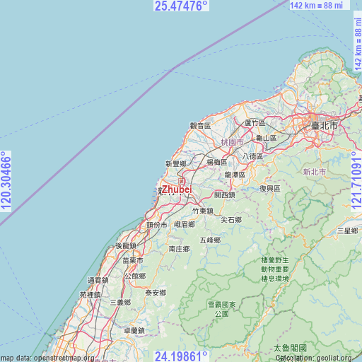
Zhubei GPS coordinates[2]
24° 50' 17.988" North, 121° 0' 28.008" East
| Map corner | latitude | longitude |
|---|---|---|
| Upper-left | 25.47476°, | 120.30466° |
| Center: | 24.83833°, | 121.00778° |
| Lower-right: | 24.19861°, | 121.71091° |
| Map W x H: | 141.9×141.9 km | = 88.2×88.2mi |
| max Lat: | 26.15039° ⇑24.3% North |
| Zhubei: | 24.83833° |
| min Lat: | ⇓75.7% South 22.00417° |
| min Long | Zhubei | max Long |
| 118.31712° | 121.00778° | 121.84424° |
| W 67.6%⇐ | ⇒32.4% E |
Elevation
Elevation of Zhubei is 30 m = 98 ft, and this is 48.5 m = 159 ft below average elevation for this country.
| Max E: |
505 m = 1657 ft | 51.4% |
| Avg. | 78.5 m = 258 ft | |
| Zhubei | 30 m = 98 ft | |
Min E: |
8 m = 26 ft | 48.6% |
See also: Taiwan elevation on elevation.city.
Geographical zone
Zhubei is located in North temperate zone (between Tropic of Cancer and the Arctic Circle). Distance of this Northern Tropic circle is 155.8 km =96.8 mi to South.| Distance of | km | miles | from Zhubei |
|---|---|---|---|
| North Pole | 7245.3 | 4502 | to North |
| Arctic Circle | 4639.4 | 2882.8 | to North |
| Tropic Cancer | 155.8 | 96.8 | to South |
| Equator | 2761.8 | 1716.1 | to South |


Nearby cities:
15 places around Zhubei: (largest is in red/bold)
• Banqiao
50.3 km =31.3 mi,  67°
67°
• Chang-hua
96.3 km =59.8 mi,  207°
207°
• Daxi
29 km =18 mi,  79°
79°
• Fengyuan
71.7 km =44.6 mi,  204°
204°
• Hsinchu
5.5 km =3.4 mi,  225°
225°
• Jiufen
89.5 km =55.6 mi, 70°
• Keelung
80.7 km =50.1 mi, 66°
• Miaoli
35.7 km =22.2 mi, 211°
• Puli
97 km =60.3 mi,  182°
182°
• Taichung
83.6 km =51.9 mi, 203°
• Taipei
57.7 km =35.9 mi, 66°
• Taoyuan
35.6 km =22.1 mi,  61°
61°
• Taoyuan City
33.9 km =21.1 mi, 59°
• Xindian
55.3 km =34.4 mi, 75°
• Yilan
75.8 km =47.1 mi,  96°
96°
Sources, notices
• [Note1] Compared only with cities in Taiwan existing in our database
• [Src1] Map data: © OpenStreetMap contributors (CC-BY-SA)
• [Src2] Other city data from geonames.org with taken over terms of usage.
• [Src3] Geographical zone / Annual Mean Temperature by Robert A. Rohde @ Wikipedia
