Keelung geodata
Keelung (Taiwan) is a seat of a second-order administrative division; located in Taiwan in Asia/Taipei (GMT+8) time zone. With population of 397,515 people, there are 7 cities with bigger population in this country. Compared to other cities in Taiwan, 97.3% of cities are located further ↓South; 94.6% of cities are located further ←West and 78.4% of cities have higher elevation than Keelung. Note1


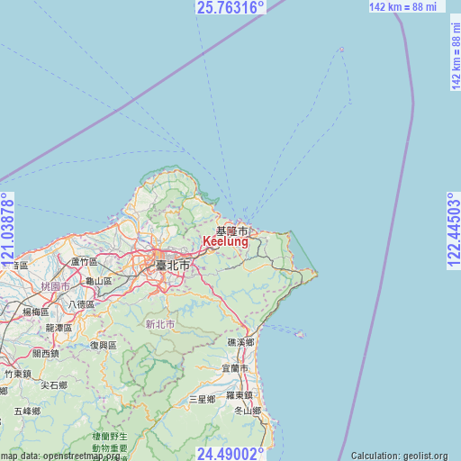
Keelung GPS coordinates[2]
25° 7' 41.7" North, 121° 44' 30.84" East
| Map corner | latitude | longitude |
|---|---|---|
| Upper-left | 25.76316°, | 121.03878° |
| Center: | 25.12825°, | 121.7419° |
| Lower-right: | 24.49002°, | 122.44503° |
| Map W x H: | 141.6×141.6 km | = 88×88mi |
| max Lat: | 26.15039° ⇑2.7% North |
| Keelung: | 25.12825° |
| min Lat: | ⇓97.3% South 22.00417° |
| min Long | Keelung | max Long |
| 118.31712° | 121.7419° | 121.84424° |
| W 94.6%⇐ | ⇒5.4% E |
Elevation
Elevation of Keelung is 17 m = 56 ft, and this is 61.5 m = 202 ft below average elevation for this country.
| Max E: |
505 m = 1657 ft | 78.4% |
| Avg. | 78.5 m = 258 ft | |
| Keelung | 17 m = 56 ft | |
Min E: |
8 m = 26 ft | 21.6% |
See also: Keelung elevation on elevation.city.
Geographical zone
Keelung is located in North temperate zone (between Tropic of Cancer and the Arctic Circle). Distance of this Northern Tropic circle is 188.1 km =116.9 mi to South.| Distance of | km | miles | from Keelung |
|---|---|---|---|
| North Pole | 7213.1 | 4482 | to North |
| Arctic Circle | 4607.2 | 2862.8 | to North |
| Tropic Cancer | 188.1 | 116.9 | to South |
| Equator | 2794 | 1736.1 | to South |


Nearby cities:
15 places around Keelung: (largest is in red/bold)
• Banqiao
30.4 km =18.9 mi,  245°
245°
• Daxi
53 km =32.9 mi,  239°
239°
• Fengyuan
142.3 km =88.4 mi,  226°
226°
• Hsinchu
85.9 km =53.4 mi, 245°
• Hualien City
128.8 km =80 mi,  186°
186°
• Jiufen
10.5 km =6.5 mi,  101°
101°
• Miaoli
111.9 km =69.5 mi, 235°
• Puli
151 km =93.8 mi,  211°
211°
• Taichung
152.8 km =94.9 mi,  224°
224°
• Taipei
23 km =14.3 mi, 247°
• Taoyuan
45.3 km =28.1 mi, 250°
• Taoyuan City
47.2 km =29.3 mi, 251°
• Xindian
27.7 km =17.2 mi, 227°
• Yilan
41.3 km =25.7 mi,  178°
178°
• Zhubei
80.7 km =50.1 mi, 246°
Sources, notices
• [Note1] Compared only with cities in Taiwan existing in our database
• [Src1] Map data: © OpenStreetMap contributors (CC-BY-SA)
• [Src2] Other city data from geonames.org with taken over terms of usage.
• [Src3] Geographical zone / Annual Mean Temperature by Robert A. Rohde @ Wikipedia
