Namalenga geodata
Namalenga (Mtwara) is a populated place; located in Tanzania in Africa/Dar_es_Salaam (GMT+3) time zone. With population of 11,204 people, there are 224 cities with bigger population in this country. Compared to other cities in Tanzania, 98.6% of cities are located further ↑North; 86% of cities are located further ←West and 81.1% of cities have higher elevation than Namalenga. Note1


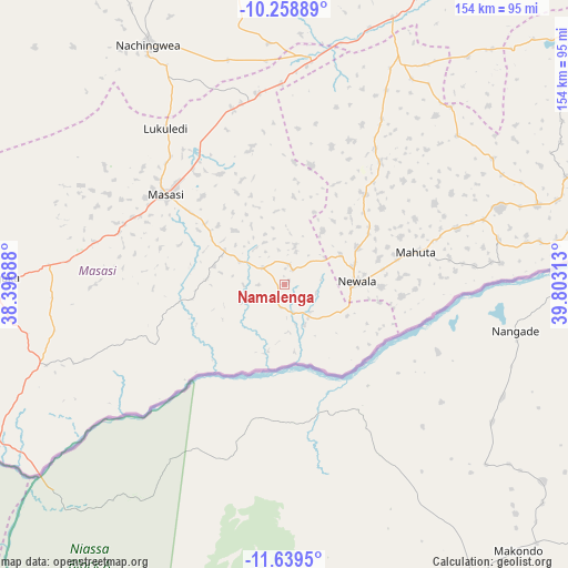
Namalenga GPS coordinates[2]
10° 57' 0" South, 39° 6' 0" East
| Map corner | latitude | longitude |
|---|---|---|
| Upper-left | -10.25889°, | 38.39688° |
| Center: | -10.95°, | 39.1° |
| Lower-right: | -11.6395°, | 39.80313° |
| Map W x H: | 153.5×153.5 km | = 95.4×95.4mi |
| max Lat: | -1.14389° ⇑98.6% North |
| Namalenga: | -10.95° |
| min Lat: | ⇓1.4% South -11.36667° |
| min Long | Namalenga | max Long |
| 29.62667° | 39.1° | 40.33333° |
| W 86%⇐ | ⇒14% E |
Elevation
Elevation of Namalenga is 280 m = 919 ft, and this is 662.8 m = 2175 ft below average elevation for this country.
| Max E: |
2377 m = 7799 ft | 81.1% |
| Avg. | 942.8 m = 3093 ft | |
| Namalenga | 280 m = 919 ft | |
Min E: |
0 m = 0 ft | 18.9% |
See also: Tanzania elevation on elevation.city.
Geographical zone
Namalenga is located in South Torrid zone (between Equator and Tropic of Capricorn). Distance of Equator is 1217.5 km =756.5 mi to North.| Distance of | km | miles | from Namalenga |
|---|---|---|---|
| Equator | 1217.5 | 756.5 | to North |
| Tropic Capricorn | 1388.4 | 862.7 | to South |
| Antarctic Circle | 6183.6 | 3842.3 | to South |
| South Pole | 8789.5 | 5461.5 | to South |


Nearby cities:
15 places around Namalenga: (largest is in red/bold)
• Chiungutwa
14.7 km =9.1 mi,  300°
300°
• Kitama
73.9 km =45.9 mi,  69°
69°
• Kitangari
42 km =26.1 mi,  37°
37°
• Luchingu
26.1 km =16.2 mi,  77°
77°
• Lukuledi
53.8 km =33.4 mi,  322°
322°
• Lulindi
15.3 km =9.5 mi,  13°
13°
• Mahuta
39.3 km =24.4 mi, 76°
• Masasi
41.8 km =26 mi,  308°
308°
• Namikupa
56.1 km =34.9 mi, 76°
• Nanganga
63.2 km =39.3 mi,  4°
4°
• Nangomba
65.7 km =40.8 mi,  274°
274°
• Nanhyanga
51.9 km =32.2 mi, 71°
• Newala Kisimani
20 km =12.4 mi,  90°
90°
• Nyangao
71.4 km =44.4 mi,  16°
16°
• Tandahimba
62.3 km =38.7 mi, 69°
Sources, notices
• [Note1] Compared only with cities in Tanzania existing in our database
• [Src1] Map data: © OpenStreetMap contributors (CC-BY-SA)
• [Src2] Other city data from geonames.org with taken over terms of usage.
• [Src3] Geographical zone / Annual Mean Temperature by Robert A. Rohde @ Wikipedia
