Tandahimba geodata
Tandahimba (Mtwara) is a populated place; located in Tanzania in Africa/Dar_es_Salaam (GMT+3) time zone. With population of 17,041 people, there are 162 cities with bigger population in this country. Compared to other cities in Tanzania, 94.8% of cities are located further ↑North; 95.8% of cities are located further ←West and 80.8% of cities have higher elevation than Tandahimba. Note1


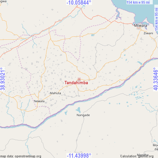
Tandahimba GPS coordinates[2]
10° 45' 0" South, 39° 37' 59.988" East
| Map corner | latitude | longitude |
|---|---|---|
| Upper-left | -10.05844°, | 38.93021° |
| Center: | -10.75°, | 39.63333° |
| Lower-right: | -11.43998°, | 40.33646° |
| Map W x H: | 153.6×153.6 km | = 95.4×95.4mi |
| max Lat: | -1.14389° ⇑94.8% North |
| Tandahimba: | -10.75° |
| min Lat: | ⇓5.2% South -11.36667° |
| min Long | Tandahimba | max Long |
| 29.62667° | 39.63333° | 40.33333° |
| W 95.8%⇐ | ⇒4.2% E |
Elevation
Elevation of Tandahimba is 284 m = 932 ft, and this is 658.8 m = 2161 ft below average elevation for this country.
| Max E: |
2377 m = 7799 ft | 80.8% |
| Avg. | 942.8 m = 3093 ft | |
| Tandahimba | 284 m = 932 ft | |
Min E: |
0 m = 0 ft | 19.2% |
See also: Tanzania elevation on elevation.city.
Geographical zone
Tandahimba is located in South Torrid zone (between Equator and Tropic of Capricorn). Distance of Equator is 1195.3 km =742.7 mi to North.| Distance of | km | miles | from Tandahimba |
|---|---|---|---|
| Equator | 1195.3 | 742.7 | to North |
| Tropic Capricorn | 1410.6 | 876.5 | to South |
| Antarctic Circle | 6205.9 | 3856.2 | to South |
| South Pole | 8811.8 | 5475.4 | to South |


Nearby cities:
15 places around Tandahimba: (largest is in red/bold)
• Chiungutwa
72.5 km =45 mi,  258°
258°
• Kitama
11.5 km =7.1 mi,  71°
71°
• Kitangari
34.6 km =21.5 mi,  288°
288°
• Luchingu
36.8 km =22.9 mi,  243°
243°
• Lulindi
55.1 km =34.2 mi, 262°
• Mahuta
23.9 km =14.9 mi, 237°
• Mingoyo
71.7 km =44.6 mi,  358°
358°
• Mtama
57.9 km =36 mi,  329°
329°
• Namalenga
62.3 km =38.7 mi,  249°
249°
• Namikupa
10 km =6.2 mi,  201°
201°
• Nanganga
66.7 km =41.4 mi,  307°
307°
• Nanhyanga
10.7 km =6.6 mi, 238°
• Nanyamba
23.1 km =14.4 mi, 71°
• Newala Kisimani
44.2 km =27.5 mi, 239°
• Nyangao
60.1 km =37.3 mi,  320°
320°
Sources, notices
• [Note1] Compared only with cities in Tanzania existing in our database
• [Src1] Map data: © OpenStreetMap contributors (CC-BY-SA)
• [Src2] Other city data from geonames.org with taken over terms of usage.
• [Src3] Geographical zone / Annual Mean Temperature by Robert A. Rohde @ Wikipedia
