Roshchino geodata
Roshchino (Republic of Crimea) is a seat of a third-order administrative division; located in Ukraine in Europe/Simferopol (GMT+3) time zone. With population of 928 people, there are 1415 cities with bigger population in this country. Compared to other cities in Ukraine, 75.2% of cities are located further ↑North; 71.4% of cities are located further ←West and 83.7% of cities have higher elevation than Roshchino. Note1
Administrative division(s):
- Level 1: Republic of Crimea
- Level 2: Dzhankoyskiy rayon
- Level 3: Roshchinskoye sel'skoye poselenye


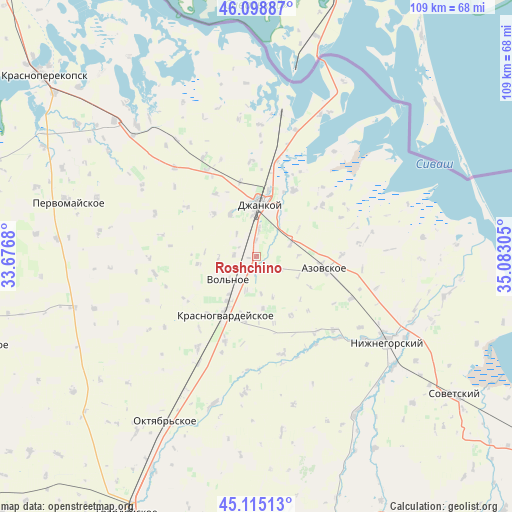
Roshchino GPS coordinates[2]
45° 36' 32.976" North, 34° 22' 47.712" East
| Map corner | latitude | longitude |
|---|---|---|
| Upper-left | 46.09887°, | 33.6768° |
| Center: | 45.60916°, | 34.37992° |
| Lower-right: | 45.11513°, | 35.08305° |
| Map W x H: | 109.4×109.4 km | = 68×68mi |
| max Lat: | 52.18903° ⇑75.2% North |
| Roshchino: | 45.60916° |
| min Lat: | ⇓24.8% South 44.39214° |
| min Long | Roshchino | max Long |
| 22.20555° | 34.37992° | 40.13222° |
| W 71.4%⇐ | ⇒28.6% E |
Elevation
Elevation of Roshchino is 33 m = 108 ft, and this is 122.8 m = 403 ft below average elevation for this country.
| Max E: |
886 m = 2907 ft | 83.7% |
| Avg. | 155.8 m = 511 ft | |
| Roshchino | 33 m = 108 ft | |
Min E: |
-3 m = -10 ft | 16.3% |
See also: Ukraine elevation on elevation.city.
Geographical zone
Roshchino is located in North temperate zone (between Tropic of Cancer and the Arctic Circle). Distance of this North polar circle is 2329.9 km =1447.7 mi to North.| Distance of | km | miles | from Roshchino |
|---|---|---|---|
| North Pole | 4935.8 | 3067 | to North |
| Arctic Circle | 2329.9 | 1447.7 | to North |
| Tropic Cancer | 2465.3 | 1531.9 | to South |
| Equator | 5071.3 | 3151.2 | to South |


Nearby cities:
15 places around Roshchino: (largest is in red/bold)
• Blizhnegorodskoye
3.5 km =2.2 mi,  0°
0°
• Blizhneye
11.5 km =7.1 mi,  213°
213°
• Dmitriyevka
10 km =6.2 mi,  350°
350°
• Dneprovka
11.7 km =7.3 mi, 353°
• Dzhankoy
11.4 km =7.1 mi, 4°
• Kondratyevo
7.7 km =4.8 mi,  71°
71°
• Mirnovka
10.6 km =6.6 mi,  328°
328°
• Novaya Zhizn’
11.1 km =6.9 mi,  56°
56°
• Novostepnoye
5.9 km =3.7 mi,  5°
5°
• Pobednoye
11.5 km =7.1 mi,  27°
27°
• Pushkino
9.9 km =6.2 mi,  215°
215°
• Rysakovo
6.3 km =3.9 mi,  319°
319°
• Vol’noye
7.7 km =4.8 mi,  230°
230°
• Voskhod
11.1 km =6.9 mi,  174°
174°
• Yarkoye Pole
4.8 km =3 mi,  275°
275°
Sources, notices
• [Note1] Compared only with cities in Ukraine existing in our database
• [Src1] Map data: © OpenStreetMap contributors (CC-BY-SA)
• [Src2] Other city data from geonames.org with taken over terms of usage.
• [Src3] Geographical zone / Annual Mean Temperature by Robert A. Rohde @ Wikipedia
