Kondratyevo geodata
Kondratyevo (Republic of Crimea) is a seat of a third-order administrative division; located in Ukraine in Europe/Simferopol (GMT+3) time zone. With population of 803 people, there are 1481 cities with bigger population in this country. Compared to other cities in Ukraine, 74.9% of cities are located further ↑North; 73% of cities are located further ←West and 90.1% of cities have higher elevation than Kondratyevo. Note1
Administrative division(s):
- Level 1: Republic of Crimea
- Level 2: Dzhankoyskiy rayon
- Level 3: Kondratyevskoye sel'skoye poselenye


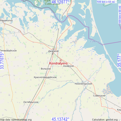
Kondratyevo GPS coordinates[2]
45° 37' 52.5" North, 34° 28' 25.932" East
| Map corner | latitude | longitude |
|---|---|---|
| Upper-left | 46.12077°, | 33.77075° |
| Center: | 45.63125°, | 34.47387° |
| Lower-right: | 45.13742°, | 35.177° |
| Map W x H: | 109.3×109.3 km | = 67.9×67.9mi |
| max Lat: | 52.18903° ⇑74.9% North |
| Kondratyevo: | 45.63125° |
| min Lat: | ⇓25.1% South 44.39214° |
| min Long | Kondratyevo | max Long |
| 22.20555° | 34.47387° | 40.13222° |
| W 73%⇐ | ⇒27% E |
Elevation
Elevation of Kondratyevo is 19 m = 62 ft, and this is 136.8 m = 449 ft below average elevation for this country.
| Max E: |
886 m = 2907 ft | 90.1% |
| Avg. | 155.8 m = 511 ft | |
| Kondratyevo | 19 m = 62 ft | |
Min E: |
-3 m = -10 ft | 9.9% |
See also: Ukraine elevation on elevation.city.
Geographical zone
Kondratyevo is located in North temperate zone (between Tropic of Cancer and the Arctic Circle). Distance of this North polar circle is 2327.5 km =1446.2 mi to North.| Distance of | km | miles | from Kondratyevo |
|---|---|---|---|
| North Pole | 4933.3 | 3065.4 | to North |
| Arctic Circle | 2327.5 | 1446.2 | to North |
| Tropic Cancer | 2467.8 | 1533.4 | to South |
| Equator | 5073.7 | 3152.7 | to South |


Nearby cities:
15 places around Kondratyevo: (largest is in red/bold)
• Azovskoye
8.8 km =5.5 mi,  124°
124°
• Blizhnegorodskoye
7.3 km =4.5 mi,  278°
278°
• Dmitriyevka
11.7 km =7.3 mi,  309°
309°
• Dzhankoy
10.9 km =6.8 mi,  324°
324°
• Mayskoye
7.3 km =4.5 mi, 123°
• Novaya Zhizn’
4.2 km =2.6 mi,  27°
27°
• Novostepnoye
7.6 km =4.7 mi,  296°
296°
• Oktyabr’
6.2 km =3.9 mi,  91°
91°
• Pobednoye
8 km =5 mi,  345°
345°
• Roshchino
7.7 km =4.8 mi,  251°
251°
• Rysakovo
11.7 km =7.3 mi, 281°
• Stal’noye
11 km =6.8 mi,  38°
38°
• Tabachnoye
11.2 km =7 mi,  100°
100°
• Yarkoye Pole
12.3 km =7.6 mi,  260°
260°
• Zarechnoye
11.7 km =7.3 mi,  3°
3°
Sources, notices
• [Note1] Compared only with cities in Ukraine existing in our database
• [Src1] Map data: © OpenStreetMap contributors (CC-BY-SA)
• [Src2] Other city data from geonames.org with taken over terms of usage.
• [Src3] Geographical zone / Annual Mean Temperature by Robert A. Rohde @ Wikipedia
