Botanicheskoye geodata
Botanicheskoye (Republic of Crimea) is a seat of a third-order administrative division; located in Ukraine in Europe/Simferopol (GMT+3) time zone. With population of 1,661 people, there are 1180 cities with bigger population in this country. Compared to other cities in Ukraine, 71.9% of cities are located further ↑North; 52.4% of cities are located further ←West and 95.3% of cities have higher elevation than Botanicheskoye. Note1
Administrative division(s):
- Level 1: Republic of Crimea
- Level 2: Razdol’nenskiy rayon
- Level 3: Botanicheskoye sel'skoye poselenye


Botanicheskoye GPS coordinates[2]
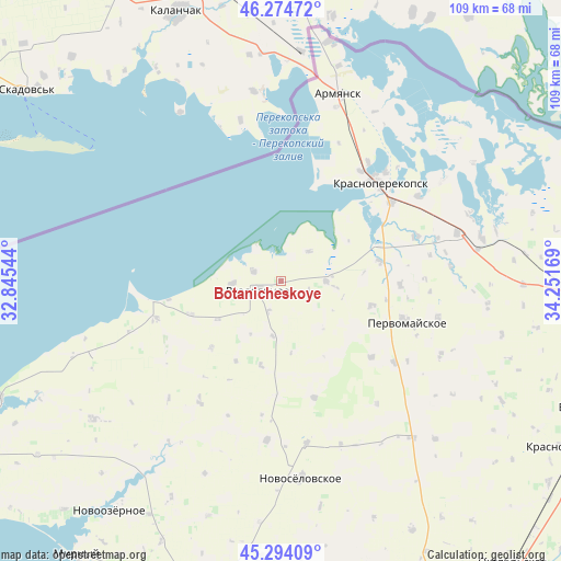
45° 47' 11.616" North, 33° 32' 54.816" East
| Map corner | latitude | longitude |
|---|---|---|
| Upper-left | 46.27472°, | 32.84544° |
| Center: | 45.78656°, | 33.54856° |
| Lower-right: | 45.29409°, | 34.25169° |
| Map W x H: | 109×109 km | = 67.7×67.7mi |
| max Lat: | 52.18903° ⇑71.9% North |
| Botanicheskoye: | 45.78656° |
| min Lat: | ⇓28.1% South 44.39214° |
| min Long | Botanicheskoye | max Long |
| 22.20555° | 33.54856° | 40.13222° |
| W 52.4%⇐ | ⇒47.6% E |
Elevation
Elevation of Botanicheskoye is 11 m = 36 ft, and this is 144.8 m = 475 ft below average elevation for this country.
| Max E: |
886 m = 2907 ft | 95.3% |
| Avg. | 155.8 m = 511 ft | |
| Botanicheskoye | 11 m = 36 ft | |
Min E: |
-3 m = -10 ft | 4.7% |
See also: Ukraine elevation on elevation.city.
Geographical zone
Botanicheskoye is located in North temperate zone (between Tropic of Cancer and the Arctic Circle). Distance of this North polar circle is 2310.2 km =1435.5 mi to North.| Distance of | km | miles | from Botanicheskoye |
|---|---|---|---|
| North Pole | 4916.1 | 3054.7 | to North |
| Arctic Circle | 2310.2 | 1435.5 | to North |
| Tropic Cancer | 2485.1 | 1544.2 | to South |
| Equator | 5091 | 3163.4 | to South |


Nearby cities:
15 places around Botanicheskoye: (largest is in red/bold)
• Chernyshevo
9.3 km =5.8 mi,  266°
266°
• Ilyinka
19.4 km =12.1 mi,  79°
79°
• Kalinino
18.4 km =11.4 mi,  105°
105°
• Kovyl’noye
10.8 km =6.7 mi,  188°
188°
• Kropotkino
5.6 km =3.5 mi,  290°
290°
• Kukushkino
14.4 km =8.9 mi,  238°
238°
• Kumovo
7.9 km =4.9 mi,  43°
43°
• Ogni
12.6 km =7.8 mi,  259°
259°
• Orlovka
18.8 km =11.7 mi,  225°
225°
• Razdol’noye
5 km =3.1 mi,  249°
249°
• Ruch’i
8.7 km =5.4 mi,  90°
90°
• Senokosnoye
6.5 km =4 mi,  203°
203°
• Serebryanka
16.9 km =10.5 mi, 193°
• Slavyanskoye
18.8 km =11.7 mi, 249°
• Stepnoye
23 km =14.3 mi,  130°
130°
Sources, notices
• [Note1] Compared only with cities in Ukraine existing in our database
• [Src1] Map data: © OpenStreetMap contributors (CC-BY-SA)
• [Src2] Other city data from geonames.org with taken over terms of usage.
• [Src3] Geographical zone / Annual Mean Temperature by Robert A. Rohde @ Wikipedia
