Oktyabr'skoye geodata
Oktyabr'skoye (Republic of Crimea) is a seat of a third-order administrative division; located in Ukraine in Europe/Simferopol (GMT+3) time zone. With population of 1,415 people, there are 1235 cities with bigger population in this country. Compared to other cities in Ukraine, 81% of cities are located further ↑North; 89.2% of cities are located further ←West and 79% of cities have higher elevation than Oktyabr'skoye. Note1
Administrative division(s):
- Level 1: Republic of Crimea
- Level 2: Lenine Raion
- Level 3: Oktyabr'skoye sel'skoye poselenye


Oktyabr'skoye GPS coordinates[2]
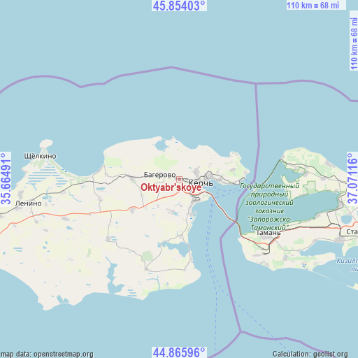
45° 21' 43.74" North, 36° 22' 4.908" East
| Map corner | latitude | longitude |
|---|---|---|
| Upper-left | 45.85403°, | 35.66491° |
| Center: | 45.36215°, | 36.36803° |
| Lower-right: | 44.86596°, | 37.07116° |
| Map W x H: | 109.9×109.9 km | = 68.3×68.3mi |
| max Lat: | 52.18903° ⇑81% North |
| Oktyabr'skoye: | 45.36215° |
| min Lat: | ⇓19% South 44.39214° |
| min Long | Oktyabr'skoye | max Long |
| 22.20555° | 36.36803° | 40.13222° |
| W 89.2%⇐ | ⇒10.8% E |
Elevation
Elevation of Oktyabr'skoye is 46 m = 151 ft, and this is 109.8 m = 360 ft below average elevation for this country.
| Max E: |
886 m = 2907 ft | 79% |
| Avg. | 155.8 m = 511 ft | |
| Oktyabr'skoye | 46 m = 151 ft | |
Min E: |
-3 m = -10 ft | 21% |
See also: Ukraine elevation on elevation.city.
Geographical zone
Oktyabr'skoye is located in North temperate zone (between Tropic of Cancer and the Arctic Circle). Distance of this North polar circle is 2357.4 km =1464.8 mi to North.| Distance of | km | miles | from Oktyabr'skoye |
|---|---|---|---|
| North Pole | 4963.3 | 3084.1 | to North |
| Arctic Circle | 2357.4 | 1464.8 | to North |
| Tropic Cancer | 2437.9 | 1514.8 | to South |
| Equator | 5043.8 | 3134.1 | to South |


Nearby cities:
15 places around Oktyabr'skoye: (largest is in red/bold)
• Baherove
5.7 km =3.5 mi,  283°
283°
• Belinskoye
22.4 km =13.9 mi,  273°
273°
• Bondarenkovo
10.3 km =6.4 mi,  65°
65°
• Chelyadinovo
17.2 km =10.7 mi,  177°
177°
• Chistopolye
14.5 km =9 mi, 271°
• Glazovka
16.8 km =10.4 mi,  80°
80°
• Gornostayevka
17 km =10.6 mi,  236°
236°
• Kerch
8.4 km =5.2 mi,  96°
96°
• Marfovka
28.3 km =17.6 mi,  229°
229°
• Maryevka
29.4 km =18.3 mi,  199°
199°
• Novonikolayevka
25 km =15.5 mi,  256°
256°
• Ostanino
35.8 km =22.2 mi, 263°
• Priozyornoye
10.6 km =6.6 mi,  194°
194°
• Voykovo
5.9 km =3.7 mi, 66°
• Zavetnoye
26.7 km =16.6 mi,  174°
174°
Sources, notices
• [Note1] Compared only with cities in Ukraine existing in our database
• [Src1] Map data: © OpenStreetMap contributors (CC-BY-SA)
• [Src2] Other city data from geonames.org with taken over terms of usage.
• [Src3] Geographical zone / Annual Mean Temperature by Robert A. Rohde @ Wikipedia
