Bondarenkovo geodata
Bondarenkovo (Republic of Crimea) is a populated place; located in Ukraine in Europe/Simferopol (GMT+3) time zone. With population of 600 people, there are 1583 cities with bigger population in this country. Compared to other cities in Ukraine, 79.6% of cities are located further ↑North; 89.6% of cities are located further ←West and 80.6% of cities have higher elevation than Bondarenkovo. Note1
Administrative division(s):
- Level 1: Republic of Crimea
- Level 2: Lenine Raion
- Level 3: Voykovskoye sel'skoye poselenye


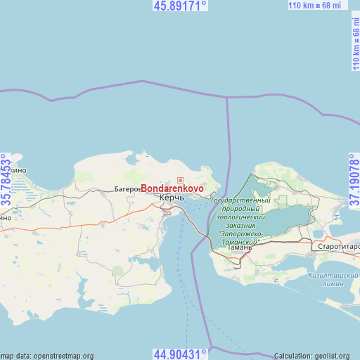
Bondarenkovo GPS coordinates[2]
45° 24' 0.612" North, 36° 29' 15.54" East
| Map corner | latitude | longitude |
|---|---|---|
| Upper-left | 45.89171°, | 35.78453° |
| Center: | 45.40017°, | 36.48765° |
| Lower-right: | 44.90431°, | 37.19078° |
| Map W x H: | 109.8×109.8 km | = 68.2×68.2mi |
| max Lat: | 52.18903° ⇑79.6% North |
| Bondarenkovo: | 45.40017° |
| min Lat: | ⇓20.4% South 44.39214° |
| min Long | Bondarenkovo | max Long |
| 22.20555° | 36.48765° | 40.13222° |
| W 89.6%⇐ | ⇒10.4% E |
Elevation
Elevation of Bondarenkovo is 41 m = 135 ft, and this is 114.8 m = 377 ft below average elevation for this country.
| Max E: |
886 m = 2907 ft | 80.6% |
| Avg. | 155.8 m = 511 ft | |
| Bondarenkovo | 41 m = 135 ft | |
Min E: |
-3 m = -10 ft | 19.4% |
See also: Ukraine elevation on elevation.city.
Geographical zone
Bondarenkovo is located in North temperate zone (between Tropic of Cancer and the Arctic Circle). Distance of this North polar circle is 2353.1 km =1462.1 mi to North.| Distance of | km | miles | from Bondarenkovo |
|---|---|---|---|
| North Pole | 4959 | 3081.4 | to North |
| Arctic Circle | 2353.1 | 1462.1 | to North |
| Tropic Cancer | 2442.1 | 1517.5 | to South |
| Equator | 5048 | 3136.7 | to South |


Nearby cities:
15 places around Bondarenkovo: (largest is in red/bold)
• Baherove
15.2 km =9.4 mi,  259°
259°
• Belinskoye
31.8 km =19.8 mi, 264°
• Chelyadinovo
23.1 km =14.4 mi,  202°
202°
• Chistopolye
24.1 km =15 mi, 260°
• Glazovka
7.3 km =4.5 mi,  100°
100°
• Gornostayevka
27.2 km =16.9 mi,  240°
240°
• Kerch
5.3 km =3.3 mi,  191°
191°
• Marfovka
38.2 km =23.7 mi,  234°
234°
• Maryevka
37.3 km =23.2 mi,  211°
211°
• Novonikolayevka
35.1 km =21.8 mi,  253°
253°
• Oktyabr'skoye
10.3 km =6.4 mi, 245°
• Ostanino
45.6 km =28.3 mi, 259°
• Priozyornoye
18.8 km =11.7 mi,  219°
219°
• Voykovo
4.4 km =2.7 mi, 244°
• Zavetnoye
31.6 km =19.6 mi, 192°
Sources, notices
• [Note1] Compared only with cities in Ukraine existing in our database
• [Src1] Map data: © OpenStreetMap contributors (CC-BY-SA)
• [Src2] Other city data from geonames.org with taken over terms of usage.
• [Src3] Geographical zone / Annual Mean Temperature by Robert A. Rohde @ Wikipedia
