Novoandreyevka geodata
Novoandreyevka (Republic of Crimea) is a seat of a third-order administrative division; located in Ukraine in Europe/Simferopol (GMT+3) time zone. With population of 2,778 people, there are 994 cities with bigger population in this country. Compared to other cities in Ukraine, 85.9% of cities are located further ↑North; 65.3% of cities are located further ←West and 59.1% of cities have higher elevation than Novoandreyevka. Note1
Administrative division(s):
- Level 1: Republic of Crimea
- Level 2: Simferopol Raion
- Level 3: Novoandreevskoye sel'skoye poselenye


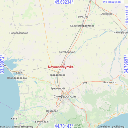
Novoandreyevka GPS coordinates[2]
45° 11' 56.544" North, 34° 5' 37.824" East
| Map corner | latitude | longitude |
|---|---|---|
| Upper-left | 45.69234°, | 33.39072° |
| Center: | 45.19904°, | 34.09384° |
| Lower-right: | 44.70143°, | 34.79697° |
| Map W x H: | 110.2×110.2 km | = 68.5×68.5mi |
| max Lat: | 52.18903° ⇑85.9% North |
| Novoandreyevka: | 45.19904° |
| min Lat: | ⇓14.1% South 44.39214° |
| min Long | Novoandreyevka | max Long |
| 22.20555° | 34.09384° | 40.13222° |
| W 65.3%⇐ | ⇒34.7% E |
Elevation
Elevation of Novoandreyevka is 108 m = 354 ft, and this is 47.8 m = 157 ft below average elevation for this country.
| Max E: |
886 m = 2907 ft | 59.1% |
| Avg. | 155.8 m = 511 ft | |
| Novoandreyevka | 108 m = 354 ft | |
Min E: |
-3 m = -10 ft | 40.9% |
See also: Ukraine elevation on elevation.city.
Geographical zone
Novoandreyevka is located in North temperate zone (between Tropic of Cancer and the Arctic Circle). Distance of this North polar circle is 2375.5 km =1476.1 mi to North.| Distance of | km | miles | from Novoandreyevka |
|---|---|---|---|
| North Pole | 4981.4 | 3095.3 | to North |
| Arctic Circle | 2375.5 | 1476.1 | to North |
| Tropic Cancer | 2419.7 | 1503.5 | to South |
| Equator | 5025.7 | 3122.8 | to South |


Nearby cities:
15 places around Novoandreyevka: (largest is in red/bold)
• Amurskoye
9.2 km =5.7 mi,  17°
17°
• Chaykino
13 km =8.1 mi,  182°
182°
• Hvardiiske
10.7 km =6.6 mi,  211°
211°
• Klyonovka
11.5 km =7.1 mi,  136°
136°
• Krasna Zor'ka
8.3 km =5.2 mi, 210°
• Krasnoye
6.6 km =4.1 mi, 179°
• Krasnoznamenka
12.2 km =7.6 mi,  323°
323°
• Leninskoye
8.4 km =5.2 mi,  336°
336°
• Novoalekseyevka
10.5 km =6.5 mi,  7°
7°
• Novozhilovka
11.7 km =7.3 mi,  111°
111°
• Novozuyevka
6.5 km =4 mi,  47°
47°
• Oktyabr’skoye
10.5 km =6.5 mi, 18°
• Pervomayskoye
9.9 km =6.2 mi,  193°
193°
• Shirokoye
3.4 km =2.1 mi,  272°
272°
• Zhuravlyovka
8 km =5 mi,  251°
251°
Sources, notices
• [Note1] Compared only with cities in Ukraine existing in our database
• [Src1] Map data: © OpenStreetMap contributors (CC-BY-SA)
• [Src2] Other city data from geonames.org with taken over terms of usage.
• [Src3] Geographical zone / Annual Mean Temperature by Robert A. Rohde @ Wikipedia
