Oktyabr’skoye geodata
Oktyabr’skoye (Republic of Crimea) is a seat of a third-order administrative division; located in Ukraine in Europe/Simferopol (GMT+3) time zone. With population of 10,244 people, there are 351 cities with bigger population in this country. Compared to other cities in Ukraine, 82.9% of cities are located further ↑North; 66.2% of cities are located further ←West and 65.1% of cities have higher elevation than Oktyabr’skoye. Note1
Administrative division(s):
- Level 1: Republic of Crimea
- Level 2: Krasnohvardiiske Raion
- Level 3: Oktyabr'skoye sel'skoye poselenye


Oktyabr’skoye GPS coordinates[2]
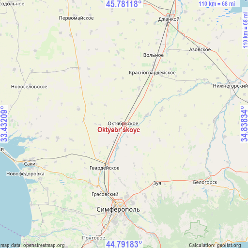
45° 17' 19.176" North, 34° 8' 6.756" East
| Map corner | latitude | longitude |
|---|---|---|
| Upper-left | 45.78118°, | 33.43209° |
| Center: | 45.28866°, | 34.13521° |
| Lower-right: | 44.79183°, | 34.83834° |
| Map W x H: | 110×110 km | = 68.4×68.4mi |
| max Lat: | 52.18903° ⇑82.9% North |
| Oktyabr’skoye: | 45.28866° |
| min Lat: | ⇓17.1% South 44.39214° |
| min Long | Oktyabr’skoye | max Long |
| 22.20555° | 34.13521° | 40.13222° |
| W 66.2%⇐ | ⇒33.8% E |
Elevation
Elevation of Oktyabr’skoye is 90 m = 295 ft, and this is 65.8 m = 216 ft below average elevation for this country.
| Max E: |
886 m = 2907 ft | 65.1% |
| Avg. | 155.8 m = 511 ft | |
| Oktyabr’skoye | 90 m = 295 ft | |
Min E: |
-3 m = -10 ft | 34.9% |
See also: Ukraine elevation on elevation.city.
Geographical zone
Oktyabr’skoye is located in North temperate zone (between Tropic of Cancer and the Arctic Circle). Distance of this North polar circle is 2365.5 km =1469.9 mi to North.| Distance of | km | miles | from Oktyabr’skoye |
|---|---|---|---|
| North Pole | 4971.4 | 3089.1 | to North |
| Arctic Circle | 2365.5 | 1469.9 | to North |
| Tropic Cancer | 2429.7 | 1509.7 | to South |
| Equator | 5035.6 | 3129 | to South |


Nearby cities:
15 places around Oktyabr’skoye: (largest is in red/bold)
• Amurskoye
1.3 km =0.8 mi,  205°
205°
• Dubrovskoye
11.4 km =7.1 mi,  355°
355°
• Komarovka
7.9 km =4.9 mi,  13°
13°
• Kotel’nikovo
12.1 km =7.5 mi,  315°
315°
• Krasnoznamenka
10.6 km =6.6 mi,  268°
268°
• Krasny Partizan
14.5 km =9 mi,  27°
27°
• Leninskoye
7 km =4.3 mi,  251°
251°
• Novoalekseyevka
1.9 km =1.2 mi,  283°
283°
• Novoandreyevka
10.5 km =6.5 mi,  198°
198°
• Novozuyevka
5.8 km =3.6 mi,  164°
164°
• Poltavka
7.9 km =4.9 mi, 28°
• Pyatikhatka
10.1 km =6.3 mi,  67°
67°
• Shirokoye
11.8 km =7.3 mi, 213°
• Timoshenko
12.6 km =7.8 mi, 271°
• Udachnoye
16 km =9.9 mi,  45°
45°
Sources, notices
• [Note1] Compared only with cities in Ukraine existing in our database
• [Src1] Map data: © OpenStreetMap contributors (CC-BY-SA)
• [Src2] Other city data from geonames.org with taken over terms of usage.
• [Src3] Geographical zone / Annual Mean Temperature by Robert A. Rohde @ Wikipedia
