Kotsyubyns’ke geodata
Kotsyubyns’ke (Kyiv City) is a populated place; located in Ukraine in Europe/Kiev (GMT+3) time zone. With population of 13,934 people, there are 271 cities with bigger population in this country. Compared to other cities in Ukraine, 90.7% of cities are located further ↓South; 65.9% of cities are located further →East and 56.3% of cities have lower elevation than Kotsyubyns’ke. Note1


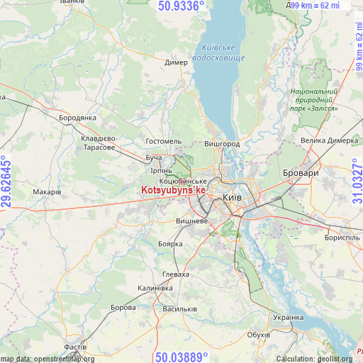
Kotsyubyns’ke GPS coordinates[2]
50° 29' 18.096" North, 30° 19' 46.452" East
| Map corner | latitude | longitude |
|---|---|---|
| Upper-left | 50.9336°, | 29.62645° |
| Center: | 50.48836°, | 30.32957° |
| Lower-right: | 50.03889°, | 31.0327° |
| Map W x H: | 99.5×99.5 km | = 61.8×61.8mi |
| max Lat: | 52.18903° ⇑9.3% North |
| Kotsyubyns’ke: | 50.48836° |
| min Lat: | ⇓90.7% South 44.39214° |
| min Long | Kotsyubyns’ke | max Long |
| 22.20555° | 30.32957° | 40.13222° |
| W 34.1%⇐ | ⇒65.9% E |
Elevation
Elevation of Kotsyubyns’ke is 156 m = 512 ft, and this is 0.19999999999999 m = 1 ft above average elevation for this country.
| Max E: |
886 m = 2907 ft | 43.7% |
| Kotsyubyns’ke | 156 m 512 ft | |
| Avg. | 155.8 m = 511 ft | |
Min E: |
-3 m = -10 ft | 56.3% |
See also: Ukraine elevation on elevation.city.
Geographical zone
Kotsyubyns’ke is located in North temperate zone (between Tropic of Cancer and the Arctic Circle). Distance of this North polar circle is 1787.4 km =1110.6 mi to North.| Distance of | km | miles | from Kotsyubyns’ke |
|---|---|---|---|
| North Pole | 4393.3 | 2729.9 | to North |
| Arctic Circle | 1787.4 | 1110.6 | to North |
| Tropic Cancer | 3007.9 | 1869 | to South |
| Equator | 5613.8 | 3488.3 | to South |


Nearby cities:
15 places around Kotsyubyns’ke: (largest is in red/bold)
• Bobrytsya
18.3 km =11.4 mi,  212°
212°
• Boyarka
19 km =11.8 mi,  186°
186°
• Bucha
10.3 km =6.4 mi,  306°
306°
• Chabany
17.7 km =11 mi,  157°
157°
• Horenka
7.7 km =4.8 mi,  1°
1°
• Hostomel
10 km =6.2 mi,  332°
332°
• Irpin
6.7 km =4.2 mi,  303°
303°
• Khotiv
20.1 km =12.5 mi,  150°
150°
• Kriukivschina
13.3 km =8.3 mi,  167°
167°
• Kyiv
14.2 km =8.8 mi,  105°
105°
• Novi Petrivtsi
17.4 km =10.8 mi,  27°
27°
• Sofiyivska Borschagivka
9.1 km =5.7 mi, 162°
• Vorzel’
13.9 km =8.6 mi, 296°
• Vyshhorod
15.6 km =9.7 mi,  46°
46°
• Vyshneve
11.4 km =7.1 mi, 165°
Sources, notices
• [Note1] Compared only with cities in Ukraine existing in our database
• [Src1] Map data: © OpenStreetMap contributors (CC-BY-SA)
• [Src2] Other city data from geonames.org with taken over terms of usage.
• [Src3] Geographical zone / Annual Mean Temperature by Robert A. Rohde @ Wikipedia
