Sofiyivska Borschagivka geodata
Sofiyivska Borschagivka (Kyiv) is a populated place; located in Ukraine in Europe/Kiev (GMT+3) time zone. With population of 6,571 people, there are 533 cities with bigger population in this country. Compared to other cities in Ukraine, 89.8% of cities are located further ↓South; 65.6% of cities are located further →East and 58.5% of cities have lower elevation than Sofiyivska Borschagivka. Note1
Current local time in Sofiyivska Borschagivka:
01:35 PM, SundayDifference from your time zone: hours


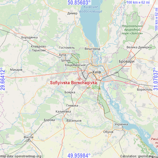
Sofiyivska Borschagivka GPS coordinates[2]
50° 24' 36.18" North, 30° 22' 2.064" East
| Map corner | latitude | longitude |
|---|---|---|
| Upper-left | 50.85603°, | 29.66412° |
| Center: | 50.41005°, | 30.36724° |
| Lower-right: | 49.95984°, | 31.07037° |
| Map W x H: | 99.6×99.6 km | = 61.9×61.9mi |
| max Lat: | 52.18903° ⇑10.2% North |
| Sofiyivska Borschagivka: | 50.41005° |
| min Lat: | ⇓89.8% South 44.39214° |
| min Long | Sofiyivska Bors | max Long |
| 22.20555° | 30.36724° | 40.13222° |
| W 34.4%⇐ | ⇒65.6% E |
Elevation
Elevation of Sofiyivska Borschagivka is 163 m = 535 ft, and this is 7.2 m = 24 ft above average elevation for this country.
| Max E: |
886 m = 2907 ft | 41.5% |
| Sofiyivska Borschagivka | 163 m 535 ft | |
| Avg. | 155.8 m = 511 ft | |
Min E: |
-3 m = -10 ft | 58.5% |
See also: Ukraine elevation on elevation.city.
Geographical zone
Sofiyivska Borschagivka is located in North temperate zone (between Tropic of Cancer and the Arctic Circle). Distance of this North polar circle is 1796.1 km =1116 mi to North.| Distance of | km | miles | from Sofiyivska Borschagivka |
|---|---|---|---|
| North Pole | 4402 | 2735.3 | to North |
| Arctic Circle | 1796.1 | 1116 | to North |
| Tropic Cancer | 2999.2 | 1863.6 | to South |
| Equator | 5605.1 | 3482.8 | to South |


Nearby cities:
15 places around Sofiyivska Borschagivka: (largest is in red/bold)
• Bobrytsya
14.3 km =8.9 mi,  242°
242°
• Boyarka
11.3 km =7 mi,  206°
206°
• Bucha
18.5 km =11.5 mi,  323°
323°
• Chabany
8.7 km =5.4 mi,  152°
152°
• Hlevakha
15.4 km =9.6 mi,  190°
190°
• Horenka
16.6 km =10.3 mi,  351°
351°
• Hostomel
19 km =11.8 mi,  337°
337°
• Irpin
14.9 km =9.3 mi,  326°
326°
• Khotiv
11.4 km =7.1 mi,  140°
140°
• Kotsyubyns’ke
9.1 km =5.7 mi, 342°
• Kriukivschina
4.3 km =2.7 mi,  178°
178°
• Kyiv
12.1 km =7.5 mi,  65°
65°
• Vorzel’
21.3 km =13.2 mi,  314°
314°
• Vyshhorod
21.3 km =13.2 mi,  24°
24°
• Vyshneve
2.3 km =1.4 mi,  174°
174°
Sources, notices
• [Note1] Compared only with cities in Ukraine existing in our database
• [Src1] Map data: © OpenStreetMap contributors (CC-BY-SA)
• [Src2] Other city data from geonames.org with taken over terms of usage.
• [Src3] Geographical zone / Annual Mean Temperature by Robert A. Rohde @ Wikipedia
