Azovskoye geodata
Azovskoye (Republic of Crimea) is a seat of a third-order administrative division; located in Ukraine in Europe/Simferopol (GMT+3) time zone. With population of 3,656 people, there are 805 cities with bigger population in this country. Compared to other cities in Ukraine, 75.5% of cities are located further ↑North; 74.3% of cities are located further ←West and 86.4% of cities have higher elevation than Azovskoye. Note1
Administrative division(s):
- Level 1: Republic of Crimea
- Level 2: Dzhankoyskiy rayon
- Level 3: Azovskoye sel'skoye poselenye


Azovskoye GPS coordinates[2]
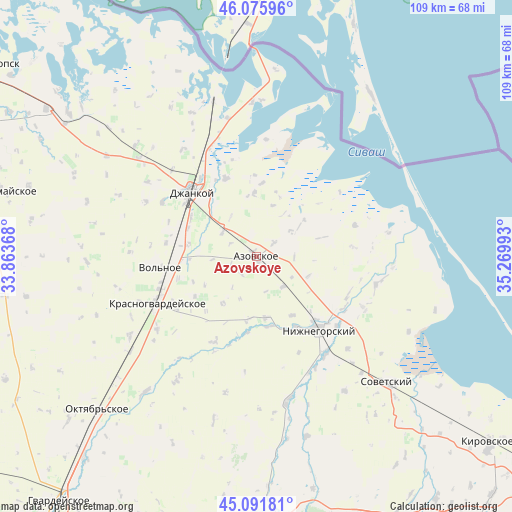
45° 35' 9.744" North, 34° 34' 0.48" East
| Map corner | latitude | longitude |
|---|---|---|
| Upper-left | 46.07596°, | 33.86368° |
| Center: | 45.58604°, | 34.5668° |
| Lower-right: | 45.09181°, | 35.26993° |
| Map W x H: | 109.4×109.4 km | = 68×68mi |
| max Lat: | 52.18903° ⇑75.5% North |
| Azovskoye: | 45.58604° |
| min Lat: | ⇓24.5% South 44.39214° |
| min Long | Azovskoye | max Long |
| 22.20555° | 34.5668° | 40.13222° |
| W 74.3%⇐ | ⇒25.7% E |
Elevation
Elevation of Azovskoye is 26 m = 85 ft, and this is 129.8 m = 426 ft below average elevation for this country.
| Max E: |
886 m = 2907 ft | 86.4% |
| Avg. | 155.8 m = 511 ft | |
| Azovskoye | 26 m = 85 ft | |
Min E: |
-3 m = -10 ft | 13.6% |
See also: Ukraine elevation on elevation.city.
Geographical zone
Azovskoye is located in North temperate zone (between Tropic of Cancer and the Arctic Circle). Distance of this North polar circle is 2332.5 km =1449.3 mi to North.| Distance of | km | miles | from Azovskoye |
|---|---|---|---|
| North Pole | 4938.4 | 3068.6 | to North |
| Arctic Circle | 2332.5 | 1449.3 | to North |
| Tropic Cancer | 2462.8 | 1530.3 | to South |
| Equator | 5068.7 | 3149.5 | to South |


Nearby cities:
15 places around Azovskoye: (largest is in red/bold)
• Borodino
11.1 km =6.9 mi,  55°
55°
• Klimovo
12.3 km =7.6 mi,  215°
215°
• Kondratyevo
8.8 km =5.5 mi,  304°
304°
• Mayskoye
1.6 km =1 mi,  312°
312°
• Mikhaylovka
8.6 km =5.3 mi,  138°
138°
• Muskatnoye
13.5 km =8.4 mi,  187°
187°
• Novaya Zhizn’
10.2 km =6.3 mi,  328°
328°
• Oktyabr’
4.9 km =3 mi,  347°
347°
• Prostornoye
12.9 km =8 mi,  52°
52°
• Roshchino
14.8 km =9.2 mi,  280°
280°
• Stal’noye
13.6 km =8.5 mi,  358°
358°
• Svetloye
9.1 km =5.7 mi, 54°
• Tabachnoye
4.8 km =3 mi, 51°
• Vladislavovka
13.2 km =8.2 mi,  171°
171°
• Zorkino
12 km =7.5 mi,  110°
110°
Sources, notices
• [Note1] Compared only with cities in Ukraine existing in our database
• [Src1] Map data: © OpenStreetMap contributors (CC-BY-SA)
• [Src2] Other city data from geonames.org with taken over terms of usage.
• [Src3] Geographical zone / Annual Mean Temperature by Robert A. Rohde @ Wikipedia
