Bakhchysarai geodata
Bakhchysarai (Republic of Crimea) is a seat of a second-order administrative division; located in Ukraine in Europe/Simferopol (GMT+3) time zone. With population of 27,351 people, there are 156 cities with bigger population in this country. Compared to other cities in Ukraine, 96.3% of cities are located further ↑North; 59.3% of cities are located further ←West and 61.4% of cities have lower elevation than Bakhchysarai. Note1
Administrative division(s):
- Level 1: Republic of Crimea
- Level 2: Bakhchysarai Raion
- Level 3: Gorodskoye poselenye Bakhchisaray


Bakhchysarai GPS coordinates[2]
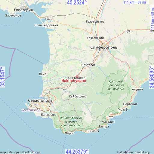
44° 45' 18.9" North, 33° 51' 28.152" East
| Map corner | latitude | longitude |
|---|---|---|
| Upper-left | 45.2524°, | 33.1547° |
| Center: | 44.75525°, | 33.85782° |
| Lower-right: | 44.25379°, | 34.56095° |
| Map W x H: | 111×111 km | = 69×69mi |
| max Lat: | 52.18903° ⇑96.3% North |
| Bakhchysarai: | 44.75525° |
| min Lat: | ⇓3.7% South 44.39214° |
| min Long | Bakhchysarai | max Long |
| 22.20555° | 33.85782° | 40.13222° |
| W 59.3%⇐ | ⇒40.7% E |
Elevation
Elevation of Bakhchysarai is 173 m = 568 ft, and this is 17.2 m = 56 ft above average elevation for this country.
| Max E: |
886 m = 2907 ft | 38.6% |
| Bakhchysarai | 173 m 568 ft | |
| Avg. | 155.8 m = 511 ft | |
Min E: |
-3 m = -10 ft | 61.4% |
See also: Ukraine elevation on elevation.city.
Geographical zone
Bakhchysarai is located in North temperate zone (between Tropic of Cancer and the Arctic Circle). Distance of this Northern Tropic circle is 2370.4 km =1472.9 mi to South.| Distance of | km | miles | from Bakhchysarai |
|---|---|---|---|
| North Pole | 5030.7 | 3125.9 | to North |
| Arctic Circle | 2424.9 | 1506.8 | to North |
| Tropic Cancer | 2370.4 | 1472.9 | to South |
| Equator | 4976.3 | 3092.1 | to South |


Nearby cities:
15 places around Bakhchysarai: (largest is in red/bold)
• Aromatnoye
5.5 km =3.4 mi,  10°
10°
• Dolinnoye
6.3 km =3.9 mi,  267°
267°
• Furmanovka
9 km =5.6 mi, 272°
• Glubokiy Yar
6.1 km =3.8 mi,  48°
48°
• Malovidnoye
6 km =3.7 mi,  319°
319°
• Noven’koye
5.1 km =3.2 mi,  246°
246°
• Novopavlovka
11.1 km =6.9 mi, 47°
• Novovasilyevka
11.3 km =7 mi,  23°
23°
• Predushchel’noye
5.5 km =3.4 mi,  169°
169°
• Prokhladnoye
10.6 km =6.6 mi,  89°
89°
• Samokhvalovo
9.2 km =5.7 mi,  32°
32°
• Sevastyanovka
9.3 km =5.8 mi,  39°
39°
• Turgenevka
6.8 km =4.2 mi,  198°
198°
• Viktorovka
5.9 km =3.7 mi,  313°
313°
• Zheleznodorozhnoye
6 km =3.7 mi,  224°
224°
In other languages:
- In Spanish: Bajchisarái, Bajchysarái
- In France: Bakhtchyssaraï, Bakhtchissaraï
- In German: Bachtschyssaraj
- In Russian: Бахчисарай
Sources, notices
• [Note1] Compared only with cities in Ukraine existing in our database
• [Src1] Map data: © OpenStreetMap contributors (CC-BY-SA)
• [Src2] Other city data from geonames.org with taken over terms of usage.
• [Src3] Geographical zone / Annual Mean Temperature by Robert A. Rohde @ Wikipedia
