Turgenevka geodata
Turgenevka (Republic of Crimea) is a populated place; located in Ukraine in Europe/Simferopol (GMT+3) time zone. With population of 1,359 people, there are 1246 cities with bigger population in this country. Compared to other cities in Ukraine, 97.2% of cities are located further ↑North; 58.6% of cities are located further ←West and 62.7% of cities have lower elevation than Turgenevka. Note1
Administrative division(s):
- Level 1: Republic of Crimea
- Level 2: Bakhchysarai Raion
- Level 3: Zheleznodorozhnenskoye sel'skoye poselenye


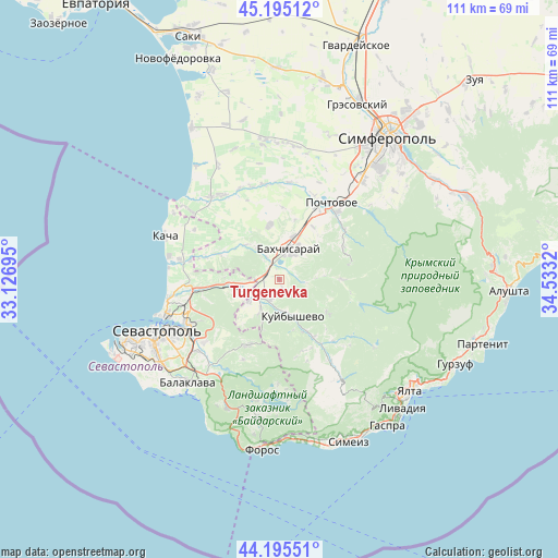
Turgenevka GPS coordinates[2]
44° 41' 50.892" North, 33° 49' 48.252" East
| Map corner | latitude | longitude |
|---|---|---|
| Upper-left | 45.19512°, | 33.12695° |
| Center: | 44.69747°, | 33.83007° |
| Lower-right: | 44.19551°, | 34.5332° |
| Map W x H: | 111.1×111.1 km | = 69×69mi |
| max Lat: | 52.18903° ⇑97.2% North |
| Turgenevka: | 44.69747° |
| min Lat: | ⇓2.8% South 44.39214° |
| min Long | Turgenevka | max Long |
| 22.20555° | 33.83007° | 40.13222° |
| W 58.6%⇐ | ⇒41.4% E |
Elevation
Elevation of Turgenevka is 178 m = 584 ft, and this is 22.2 m = 73 ft above average elevation for this country.
| Max E: |
886 m = 2907 ft | 37.3% |
| Turgenevka | 178 m 584 ft | |
| Avg. | 155.8 m = 511 ft | |
Min E: |
-3 m = -10 ft | 62.7% |
See also: Ukraine elevation on elevation.city.
Geographical zone
Turgenevka is located in North temperate zone (between Tropic of Cancer and the Arctic Circle). Distance of this Northern Tropic circle is 2364 km =1468.9 mi to South.| Distance of | km | miles | from Turgenevka |
|---|---|---|---|
| North Pole | 5037.2 | 3130 | to North |
| Arctic Circle | 2431.3 | 1510.7 | to North |
| Tropic Cancer | 2364 | 1468.9 | to South |
| Equator | 4969.9 | 3088.2 | to South |


Nearby cities:
15 places around Turgenevka: (largest is in red/bold)
• Aromatnoye
12.2 km =7.6 mi,  14°
14°
• Bakhchysarai
6.8 km =4.2 mi,  18°
18°
• Dolinnoye
7.5 km =4.7 mi,  326°
326°
• Frontovoye
8 km =5 mi,  245°
245°
• Furmanovka
9.6 km =6 mi,  314°
314°
• Kholmovka
7.4 km =4.6 mi,  233°
233°
• Krasnyi Mak
7.3 km =4.5 mi,  212°
212°
• Kuibyshevo
8.2 km =5.1 mi,  158°
158°
• Malovidnoye
11.1 km =6.9 mi,  351°
351°
• Noven’koye
5.1 km =3.2 mi, 330°
• Predushchel’noye
3.4 km =2.1 mi,  72°
72°
• Tankovoye
4.7 km =2.9 mi,  200°
200°
• Verkhnesadovoye
10.2 km =6.3 mi,  264°
264°
• Viktorovka
10.6 km =6.6 mi, 348°
• Zheleznodorozhnoye
3 km =1.9 mi,  316°
316°
Sources, notices
• [Note1] Compared only with cities in Ukraine existing in our database
• [Src1] Map data: © OpenStreetMap contributors (CC-BY-SA)
• [Src2] Other city data from geonames.org with taken over terms of usage.
• [Src3] Geographical zone / Annual Mean Temperature by Robert A. Rohde @ Wikipedia
