Aromatnoye geodata
Aromatnoye (Republic of Crimea) is a seat of a third-order administrative division; located in Ukraine in Europe/Simferopol (GMT+3) time zone. With population of 872 people, there are 1452 cities with bigger population in this country. Compared to other cities in Ukraine, 95.6% of cities are located further ↑North; 59.5% of cities are located further ←West and 88.7% of cities have lower elevation than Aromatnoye. Note1
Administrative division(s):
- Level 1: Republic of Crimea
- Level 2: Bakhchysarai Raion
- Level 3: Aromatnenskoye sel'skoye poselenye


Aromatnoye GPS coordinates[2]
44° 48' 13.428" North, 33° 52' 12.18" East
| Map corner | latitude | longitude |
|---|---|---|
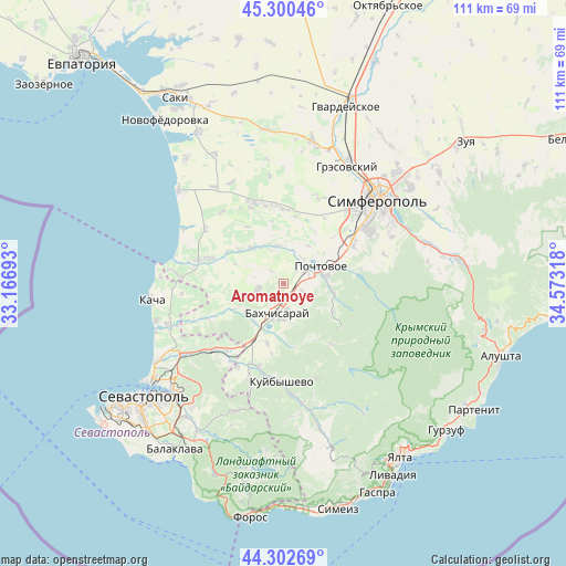
| Upper-left | 45.30046°, | 33.16693° |
| Center: | 44.80373°, | 33.87005° |
| Lower-right: | 44.30269°, | 34.57318° |
| Map W x H: | 110.9×110.9 km | = 68.9×68.9mi |
| max Lat: | 52.18903° ⇑95.6% North |
| Aromatnoye: | 44.80373° |
| min Lat: | ⇓4.4% South 44.39214° |
| min Long | Aromatnoye | max Long |
| 22.20555° | 33.87005° | 40.13222° |
| W 59.5%⇐ | ⇒40.5% E |
Elevation
Elevation of Aromatnoye is 299 m = 981 ft, and this is 143.2 m = 470 ft above average elevation for this country.
| Max E: |
886 m = 2907 ft | 11.3% |
| Aromatnoye | 299 m 981 ft | |
| Avg. | 155.8 m = 511 ft | |
Min E: |
-3 m = -10 ft | 88.7% |
See also: Ukraine elevation on elevation.city.
Geographical zone
Aromatnoye is located in North temperate zone (between Tropic of Cancer and the Arctic Circle). Distance of this Northern Tropic circle is 2375.8 km =1476.3 mi to South.| Distance of | km | miles | from Aromatnoye |
|---|---|---|---|
| North Pole | 5025.4 | 3122.6 | to North |
| Arctic Circle | 2419.5 | 1503.4 | to North |
| Tropic Cancer | 2375.8 | 1476.3 | to South |
| Equator | 4981.7 | 3095.5 | to South |


Nearby cities:
15 places around Aromatnoye: (largest is in red/bold)
• Bakhchysarai
5.5 km =3.4 mi,  190°
190°
• Bryanskoye
8.7 km =5.4 mi,  323°
323°
• Dolinnoye
9.2 km =5.7 mi,  232°
232°
• Glubokiy Yar
3.9 km =2.4 mi,  110°
110°
• Kashtany
9.5 km =5.9 mi, 318°
• Malovidnoye
4.9 km =3 mi,  260°
260°
• Noven’koye
9.3 km =5.8 mi,  217°
217°
• Novopavlovka
7.5 km =4.7 mi,  73°
73°
• Novovasilyevka
6.2 km =3.9 mi,  36°
36°
• Plodovoye
7.6 km =4.7 mi,  351°
351°
• Poshtove
8 km =5 mi,  63°
63°
• Samokhvalovo
4.6 km =2.9 mi, 60°
• Sevastyanovka
5.3 km =3.3 mi, 70°
• Skalistoye
8.6 km =5.3 mi,  80°
80°
• Viktorovka
5.4 km =3.4 mi, 255°
Sources, notices
• [Note1] Compared only with cities in Ukraine existing in our database
• [Src1] Map data: © OpenStreetMap contributors (CC-BY-SA)
• [Src2] Other city data from geonames.org with taken over terms of usage.
• [Src3] Geographical zone / Annual Mean Temperature by Robert A. Rohde @ Wikipedia
