Wilton geodata
Wilton (Alabama) is a populated place; located in United States in America/Chicago (GMT-5) time zone. With population of 687 people, there are 18811 cities with bigger population in this country. Compared to other cities in United States, 84.9% of cities are located further ↑North; 50.6% of cities are located further ←West and 65.8% of cities have higher elevation than Wilton. Note1


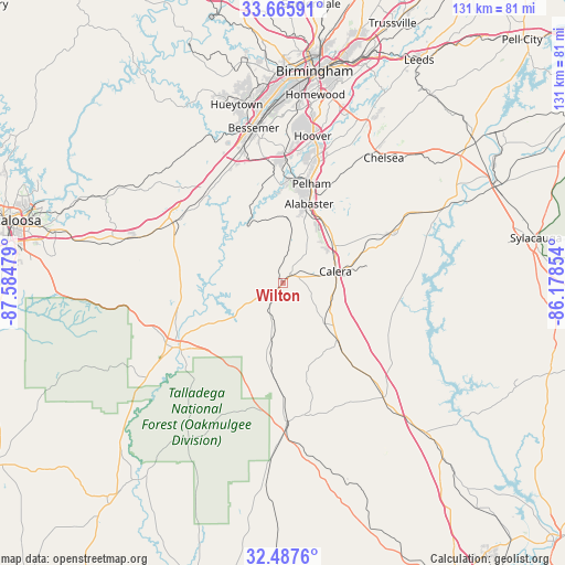
Wilton GPS coordinates[2]
33° 4' 43.428" North, 86° 52' 53.976" West
| Map corner | latitude | longitude |
|---|---|---|
| Upper-left | 33.66591°, | -87.58479° |
| Center: | 33.07873°, | -86.88166° |
| Lower-right: | 32.4876°, | -86.17854° |
| Map W x H: | 131×131 km | = 81.4×81.4mi |
| max Lat: | 71.29058° ⇑84.9% North |
| Wilton: | 33.07873° |
| min Lat: | ⇓15.1% South 19.06759° |
| min Long | Wilton | max Long |
| -171.73463° | -86.88166° | -66.98998° |
| W 50.6%⇐ | ⇒49.4% E |
Elevation
Elevation of Wilton is 124 m = 407 ft, and this is 170.8 m = 560 ft below average elevation for this country.
| Max E: |
3189 m = 10463 ft | 65.8% |
| Avg. | 294.8 m = 967 ft | |
| Wilton | 124 m = 407 ft | |
Min E: |
-60 m = -197 ft | 34.2% |
See also: United States elevation on elevation.city.
Geographical zone
Wilton is located in North temperate zone (between Tropic of Cancer and the Arctic Circle). Distance of this Northern Tropic circle is 1072.1 km =666.2 mi to South.| Distance of | km | miles | from Wilton |
|---|---|---|---|
| North Pole | 6329.1 | 3932.7 | to North |
| Arctic Circle | 3723.2 | 2313.5 | to North |
| Tropic Cancer | 1072.1 | 666.2 | to South |
| Equator | 3678 | 2285.4 | to South |


Nearby cities:
15 places around Wilton: (largest is in red/bold)
• Alabaster
19.4 km =12.1 mi,  18°
18°
• Brantleyville
15.3 km =9.5 mi,  2°
2°
• Brent
30.7 km =19.1 mi,  239°
239°
• Calera
12.2 km =7.6 mi,  77°
77°
• Centreville
26.4 km =16.4 mi, 236°
• Columbiana
27.8 km =17.3 mi,  66°
66°
• Helena
24.4 km =15.2 mi,  8°
8°
• Jemison
18.3 km =11.4 mi,  136°
136°
• Montevallo
2.9 km =1.8 mi,  33°
33°
• North Bibb
28.9 km =18 mi,  298°
298°
• Pelham
24 km =14.9 mi, 16°
• Shelby
27.9 km =17.3 mi, 82°
• Thorsby
23.8 km =14.8 mi, 139°
• West Blocton
23.1 km =14.4 mi,  280°
280°
• Woodstock
28.8 km =17.9 mi, 299°
Sources, notices
• [Note1] Compared only with cities in United States existing in our database
• [Src1] Map data: © OpenStreetMap contributors (CC-BY-SA)
• [Src2] Other city data from geonames.org with taken over terms of usage.
• [Src3] Geographical zone / Annual Mean Temperature by Robert A. Rohde @ Wikipedia
