Columbiana geodata
Columbiana (Alabama) is a seat of a second-order administrative division; located in United States in America/Chicago (GMT-5) time zone. With population of 4,168 people, there are 8027 cities with bigger population in this country. Compared to other cities in United States, 84.4% of cities are located further ↑North; 51.3% of cities are located further ←West and 57.7% of cities have higher elevation than Columbiana. Note1


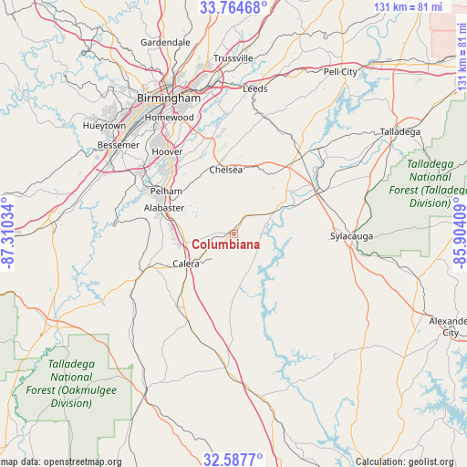
Columbiana GPS coordinates[2]
33° 10' 41.412" North, 86° 36' 25.956" West
| Map corner | latitude | longitude |
|---|---|---|
| Upper-left | 33.76468°, | -87.31034° |
| Center: | 33.17817°, | -86.60721° |
| Lower-right: | 32.5877°, | -85.90409° |
| Map W x H: | 130.9×130.9 km | = 81.3×81.3mi |
| max Lat: | 71.29058° ⇑84.4% North |
| Columbiana: | 33.17817° |
| min Lat: | ⇓15.6% South 19.06759° |
| min Long | Columbiana | max Long |
| -171.73463° | -86.60721° | -66.98998° |
| W 51.3%⇐ | ⇒48.7% E |
Elevation
Elevation of Columbiana is 167 m = 548 ft, and this is 127.8 m = 419 ft below average elevation for this country.
| Max E: |
3189 m = 10463 ft | 57.7% |
| Avg. | 294.8 m = 967 ft | |
| Columbiana | 167 m = 548 ft | |
Min E: |
-60 m = -197 ft | 42.3% |
See also: United States elevation on elevation.city.
Geographical zone
Columbiana is located in North temperate zone (between Tropic of Cancer and the Arctic Circle). Distance of this Northern Tropic circle is 1083.1 km =673 mi to South.| Distance of | km | miles | from Columbiana |
|---|---|---|---|
| North Pole | 6318 | 3925.8 | to North |
| Arctic Circle | 3712.1 | 2306.6 | to North |
| Tropic Cancer | 1083.1 | 673 | to South |
| Equator | 3689.1 | 2292.3 | to South |


Nearby cities:
15 places around Columbiana: (largest is in red/bold)
• Alabaster
20.8 km =12.9 mi,  290°
290°
• Brantleyville
25.3 km =15.7 mi,  279°
279°
• Calera
16 km =9.9 mi,  238°
238°
• Chelsea
18.1 km =11.2 mi,  353°
353°
• Childersburg
26 km =16.2 mi,  64°
64°
• Fayetteville
19.1 km =11.9 mi,  100°
100°
• Harpersville
24.2 km =15 mi,  40°
40°
• Helena
25.6 km =15.9 mi,  300°
300°
• Highland Lakes
24.8 km =15.4 mi, 350°
• Indian Springs Village
24 km =14.9 mi,  325°
325°
• Montevallo
25.4 km =15.8 mi,  250°
250°
• Pelham
22.3 km =13.9 mi, 302°
• Shelby
7.8 km =4.8 mi,  164°
164°
• Westover
20.2 km =12.6 mi,  19°
19°
• Wilsonville
13.1 km =8.1 mi, 61°
Sources, notices
• [Note1] Compared only with cities in United States existing in our database
• [Src1] Map data: © OpenStreetMap contributors (CC-BY-SA)
• [Src2] Other city data from geonames.org with taken over terms of usage.
• [Src3] Geographical zone / Annual Mean Temperature by Robert A. Rohde @ Wikipedia
