Calera geodata
Calera (Alabama) is a populated place; located in United States in America/Chicago (GMT-5) time zone. With population of 13,213 people, there are 3619 cities with bigger population in this country. Compared to other cities in United States, 84.8% of cities are located further ↑North; 50.9% of cities are located further ←West and 59.7% of cities have higher elevation than Calera. Note1


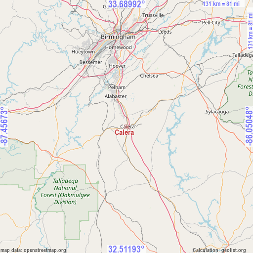
Calera GPS coordinates[2]
33° 6' 10.44" North, 86° 45' 12.96" West
| Map corner | latitude | longitude |
|---|---|---|
| Upper-left | 33.68992°, | -87.45673° |
| Center: | 33.1029°, | -86.7536° |
| Lower-right: | 32.51193°, | -86.05048° |
| Map W x H: | 131×131 km | = 81.4×81.4mi |
| max Lat: | 71.29058° ⇑84.8% North |
| Calera: | 33.1029° |
| min Lat: | ⇓15.2% South 19.06759° |
| min Long | Calera | max Long |
| -171.73463° | -86.7536° | -66.98998° |
| W 50.9%⇐ | ⇒49.1% E |
Elevation
Elevation of Calera is 156 m = 512 ft, and this is 138.8 m = 455 ft below average elevation for this country.
| Max E: |
3189 m = 10463 ft | 59.7% |
| Avg. | 294.8 m = 967 ft | |
| Calera | 156 m = 512 ft | |
Min E: |
-60 m = -197 ft | 40.3% |
See also: United States elevation on elevation.city.
Geographical zone
Calera is located in North temperate zone (between Tropic of Cancer and the Arctic Circle). Distance of this Northern Tropic circle is 1074.8 km =667.8 mi to South.| Distance of | km | miles | from Calera |
|---|---|---|---|
| North Pole | 6326.4 | 3931 | to North |
| Arctic Circle | 3720.5 | 2311.8 | to North |
| Tropic Cancer | 1074.8 | 667.8 | to South |
| Equator | 3680.7 | 2287.1 | to South |


Nearby cities:
15 places around Calera: (largest is in red/bold)
• Alabaster
16.8 km =10.4 mi,  339°
339°
• Brantleyville
16.9 km =10.5 mi,  318°
318°
• Chelsea
28.8 km =17.9 mi,  23°
23°
• Clanton
31.6 km =19.6 mi,  158°
158°
• Columbiana
16 km =9.9 mi,  58°
58°
• Fayetteville
32.7 km =20.3 mi,  81°
81°
• Helena
23.1 km =14.4 mi, 338°
• Indian Springs Village
28.1 km =17.5 mi,  359°
359°
• Jemison
15.9 km =9.9 mi,  177°
177°
• Montevallo
10.3 km =6.4 mi,  268°
268°
• Pelham
21 km =13 mi,  345°
345°
• Shelby
15.8 km =9.8 mi,  86°
86°
• Thorsby
21.1 km =13.1 mi,  170°
170°
• Wilsonville
29.1 km =18.1 mi, 59°
• Wilton
12.2 km =7.6 mi,  257°
257°
Sources, notices
• [Note1] Compared only with cities in United States existing in our database
• [Src1] Map data: © OpenStreetMap contributors (CC-BY-SA)
• [Src2] Other city data from geonames.org with taken over terms of usage.
• [Src3] Geographical zone / Annual Mean Temperature by Robert A. Rohde @ Wikipedia
