Harpersville geodata
Harpersville (Alabama) is a populated place; located in United States in America/Chicago (GMT-5) time zone. With population of 1,681 people, there are 12978 cities with bigger population in this country. Compared to other cities in United States, 83.8% of cities are located further ↑North; 51.7% of cities are located further ←West and 63.1% of cities have higher elevation than Harpersville. Note1


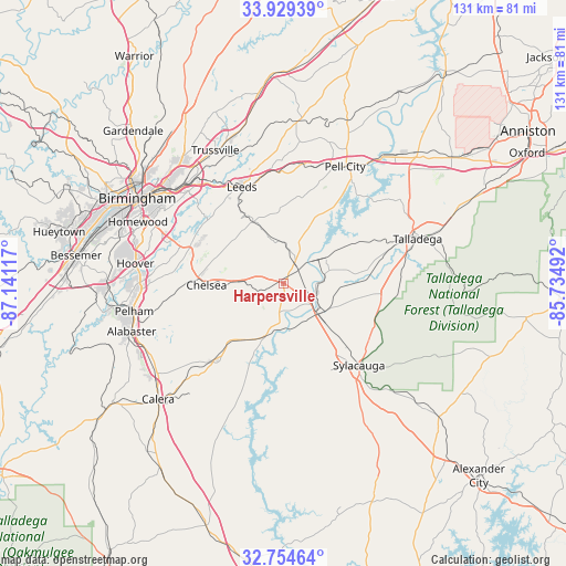
Harpersville GPS coordinates[2]
33° 20' 38.4" North, 86° 26' 16.944" West
| Map corner | latitude | longitude |
|---|---|---|
| Upper-left | 33.92939°, | -87.14117° |
| Center: | 33.344°, | -86.43804° |
| Lower-right: | 32.75464°, | -85.73492° |
| Map W x H: | 130.6×130.6 km | = 81.2×81.2mi |
| max Lat: | 71.29058° ⇑83.8% North |
| Harpersville: | 33.344° |
| min Lat: | ⇓16.2% South 19.06759° |
| min Long | Harpersville | max Long |
| -171.73463° | -86.43804° | -66.98998° |
| W 51.7%⇐ | ⇒48.3% E |
Elevation
Elevation of Harpersville is 138 m = 453 ft, and this is 156.8 m = 514 ft below average elevation for this country.
| Max E: |
3189 m = 10463 ft | 63.1% |
| Avg. | 294.8 m = 967 ft | |
| Harpersville | 138 m = 453 ft | |
Min E: |
-60 m = -197 ft | 36.9% |
See also: United States elevation on elevation.city.
Geographical zone
Harpersville is located in North temperate zone (between Tropic of Cancer and the Arctic Circle). Distance of this Northern Tropic circle is 1101.6 km =684.5 mi to South.| Distance of | km | miles | from Harpersville |
|---|---|---|---|
| North Pole | 6299.6 | 3914.4 | to North |
| Arctic Circle | 3693.7 | 2295.2 | to North |
| Tropic Cancer | 1101.6 | 684.5 | to South |
| Equator | 3707.5 | 2303.7 | to South |


Nearby cities:
15 places around Harpersville: (largest is in red/bold)
• Brook Highland
24.2 km =15 mi,  294°
294°
• Chelsea
17.9 km =11.1 mi,  268°
268°
• Childersburg
10.6 km =6.6 mi,  133°
133°
• Columbiana
24.2 km =15 mi,  220°
220°
• Dunnavant
19.3 km =12 mi,  329°
329°
• Fayetteville
22.3 km =13.9 mi,  172°
172°
• Highland Lakes
20.7 km =12.9 mi, 286°
• Mignon
24.3 km =15.1 mi,  137°
137°
• Oak Grove
21.3 km =13.2 mi, 142°
• Shoal Creek
18.7 km =11.6 mi,  301°
301°
• Sterrett
12.3 km =7.6 mi,  341°
341°
• Vandiver
15.7 km =9.8 mi, 333°
• Vincent
5.1 km =3.2 mi,  28°
28°
• Westover
9.1 km =5.7 mi, 273°
• Wilsonville
12.9 km =8 mi,  199°
199°
Sources, notices
• [Note1] Compared only with cities in United States existing in our database
• [Src1] Map data: © OpenStreetMap contributors (CC-BY-SA)
• [Src2] Other city data from geonames.org with taken over terms of usage.
• [Src3] Geographical zone / Annual Mean Temperature by Robert A. Rohde @ Wikipedia
