Hanceville geodata
Hanceville (Alabama) is a populated place; located in United States in America/Chicago (GMT-5) time zone. With population of 3,281 people, there are 9179 cities with bigger population in this country. Compared to other cities in United States, 79.8% of cities are located further ↑North; 50.9% of cities are located further ←West and 57.5% of cities have higher elevation than Hanceville. Note1


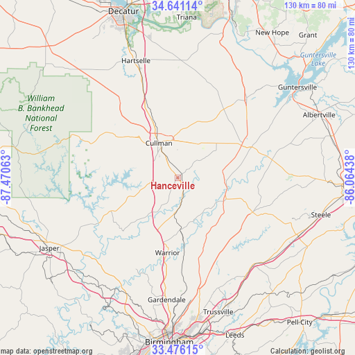
Hanceville GPS coordinates[2]
34° 3' 38.34" North, 86° 46' 3" West
| Map corner | latitude | longitude |
|---|---|---|
| Upper-left | 34.64114°, | -87.47063° |
| Center: | 34.06065°, | -86.7675° |
| Lower-right: | 33.47615°, | -86.06438° |
| Map W x H: | 129.5×129.5 km | = 80.5×80.5mi |
| max Lat: | 71.29058° ⇑79.8% North |
| Hanceville: | 34.06065° |
| min Lat: | ⇓20.2% South 19.06759° |
| min Long | Hanceville | max Long |
| -171.73463° | -86.7675° | -66.98998° |
| W 50.9%⇐ | ⇒49.1% E |
Elevation
Elevation of Hanceville is 168 m = 551 ft, and this is 126.8 m = 416 ft below average elevation for this country.
| Max E: |
3189 m = 10463 ft | 57.5% |
| Avg. | 294.8 m = 967 ft | |
| Hanceville | 168 m = 551 ft | |
Min E: |
-60 m = -197 ft | 42.5% |
See also: United States elevation on elevation.city.
Geographical zone
Hanceville is located in North temperate zone (between Tropic of Cancer and the Arctic Circle). Distance of this Northern Tropic circle is 1181.3 km =734 mi to South.| Distance of | km | miles | from Hanceville |
|---|---|---|---|
| North Pole | 6219.9 | 3864.9 | to North |
| Arctic Circle | 3614 | 2245.6 | to North |
| Tropic Cancer | 1181.3 | 734 | to South |
| Equator | 3787.2 | 2353.3 | to South |


Nearby cities:
15 places around Hanceville: (largest is in red/bold)
• Allgood
29 km =18 mi,  124°
124°
• Baileyton
26.6 km =16.5 mi,  32°
32°
• Blountsville
16.4 km =10.2 mi,  81°
81°
• Cleveland
19.1 km =11.9 mi,  113°
113°
• Cullman
14.5 km =9 mi,  331°
331°
• Dodge City
11.1 km =6.9 mi,  258°
258°
• Good Hope
10.8 km =6.7 mi,  304°
304°
• Hayden
18.7 km =11.6 mi,  177°
177°
• Holly Pond
18.8 km =11.7 mi,  47°
47°
• Locust Fork
22.1 km =13.7 mi,  140°
140°
• Smoke Rise
19.4 km =12.1 mi,  194°
194°
• South Vinemont
21.7 km =13.5 mi,  335°
335°
• Trafford
27.1 km =16.8 mi, 175°
• Warrior
27.7 km =17.2 mi, 188°
• West Point
26.5 km =16.5 mi,  318°
318°
Sources, notices
• [Note1] Compared only with cities in United States existing in our database
• [Src1] Map data: © OpenStreetMap contributors (CC-BY-SA)
• [Src2] Other city data from geonames.org with taken over terms of usage.
• [Src3] Geographical zone / Annual Mean Temperature by Robert A. Rohde @ Wikipedia
