Blountsville geodata
Blountsville (Alabama) is a populated place; located in United States in America/Chicago (GMT-5) time zone. With population of 1,697 people, there are 12922 cities with bigger population in this country. Compared to other cities in United States, 79.7% of cities are located further ↑North; 51.3% of cities are located further ←West and 55.4% of cities have lower elevation than Blountsville. Note1


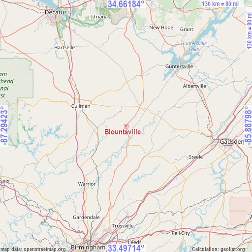
Blountsville GPS coordinates[2]
34° 4' 53.364" North, 86° 35' 27.96" West
| Map corner | latitude | longitude |
|---|---|---|
| Upper-left | 34.66184°, | -87.29423° |
| Center: | 34.08149°, | -86.5911° |
| Lower-right: | 33.49714°, | -85.88798° |
| Map W x H: | 129.5×129.5 km | = 80.5×80.5mi |
| max Lat: | 71.29058° ⇑79.7% North |
| Blountsville: | 34.08149° |
| min Lat: | ⇓20.3% South 19.06759° |
| min Long | Blountsville | max Long |
| -171.73463° | -86.5911° | -66.98998° |
| W 51.3%⇐ | ⇒48.7% E |
Elevation
Elevation of Blountsville is 220 m = 722 ft, and this is 74.8 m = 245 ft below average elevation for this country.
| Max E: |
3189 m = 10463 ft | 44.6% |
| Avg. | 294.8 m = 967 ft | |
| Blountsville | 220 m = 722 ft | |
Min E: |
-60 m = -197 ft | 55.4% |
See also: United States elevation on elevation.city.
Geographical zone
Blountsville is located in North temperate zone (between Tropic of Cancer and the Arctic Circle). Distance of this Northern Tropic circle is 1183.6 km =735.5 mi to South.| Distance of | km | miles | from Blountsville |
|---|---|---|---|
| North Pole | 6217.6 | 3863.4 | to North |
| Arctic Circle | 3611.7 | 2244.2 | to North |
| Tropic Cancer | 1183.6 | 735.5 | to South |
| Equator | 3789.5 | 2354.7 | to South |


Nearby cities:
15 places around Blountsville: (largest is in red/bold)
• Allgood
20.3 km =12.6 mi,  158°
158°
• Altoona
25.2 km =15.7 mi,  104°
104°
• Baileyton
20.2 km =12.6 mi,  354°
354°
• Cleveland
10.1 km =6.3 mi,  172°
172°
• Cullman
25.5 km =15.8 mi,  294°
294°
• Good Hope
25.4 km =15.8 mi,  278°
278°
• Hanceville
16.4 km =10.2 mi,  261°
261°
• Hayden
26 km =16.2 mi,  216°
216°
• Holly Pond
10.6 km =6.6 mi, 347°
• Joppa
24.3 km =15.1 mi,  7°
7°
• Locust Fork
19.5 km =12.1 mi,  186°
186°
• Oneonta
18.4 km =11.4 mi,  143°
143°
• Snead
18.5 km =11.5 mi,  76°
76°
• Susan Moore
15 km =9.3 mi,  89°
89°
• Walnut Grove
26.3 km =16.3 mi, 93°
Sources, notices
• [Note1] Compared only with cities in United States existing in our database
• [Src1] Map data: © OpenStreetMap contributors (CC-BY-SA)
• [Src2] Other city data from geonames.org with taken over terms of usage.
• [Src3] Geographical zone / Annual Mean Temperature by Robert A. Rohde @ Wikipedia
