Cullman geodata
Cullman (Alabama) is a seat of a second-order administrative division; located in United States in America/Chicago (GMT-5) time zone. With population of 15,350 people, there are 3174 cities with bigger population in this country. Compared to other cities in United States, 79.1% of cities are located further ↑North; 50.7% of cities are located further ←West and 61% of cities have lower elevation than Cullman. Note1


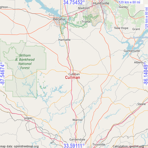
Cullman GPS coordinates[2]
34° 10' 29.352" North, 86° 50' 36.996" West
| Map corner | latitude | longitude |
|---|---|---|
| Upper-left | 34.75452°, | -87.54674° |
| Center: | 34.17482°, | -86.84361° |
| Lower-right: | 33.59111°, | -86.14049° |
| Map W x H: | 129.4×129.4 km | = 80.4×80.4mi |
| max Lat: | 71.29058° ⇑79.1% North |
| Cullman: | 34.17482° |
| min Lat: | ⇓20.9% South 19.06759° |
| min Long | Cullman | max Long |
| -171.73463° | -86.84361° | -66.98998° |
| W 50.7%⇐ | ⇒49.3% E |
Elevation
Elevation of Cullman is 244 m = 801 ft, and this is 50.8 m = 167 ft below average elevation for this country.
| Max E: |
3189 m = 10463 ft | 39% |
| Avg. | 294.8 m = 967 ft | |
| Cullman | 244 m = 801 ft | |
Min E: |
-60 m = -197 ft | 61% |
See also: United States elevation on elevation.city.
Geographical zone
Cullman is located in North temperate zone (between Tropic of Cancer and the Arctic Circle). Distance of this Northern Tropic circle is 1194 km =741.9 mi to South.| Distance of | km | miles | from Cullman |
|---|---|---|---|
| North Pole | 6207.2 | 3857 | to North |
| Arctic Circle | 3601.3 | 2237.7 | to North |
| Tropic Cancer | 1194 | 741.9 | to South |
| Equator | 3799.9 | 2361.1 | to South |


Nearby cities:
15 places around Cullman: (largest is in red/bold)
• Addison
31.2 km =19.4 mi,  275°
275°
• Baileyton
23.3 km =14.5 mi,  65°
65°
• Blountsville
25.5 km =15.8 mi,  114°
114°
• Cleveland
31.9 km =19.8 mi,  129°
129°
• Dodge City
15.4 km =9.6 mi,  194°
194°
• Eva
19.2 km =11.9 mi,  23°
23°
• Falkville
22.3 km =13.9 mi,  344°
344°
• Good Hope
6.8 km =4.2 mi,  195°
195°
• Hanceville
14.5 km =9 mi,  151°
151°
• Hartselle
31 km =19.3 mi, 344°
• Holly Pond
20.9 km =13 mi,  90°
90°
• Joppa
29.8 km =18.5 mi,  62°
62°
• Smoke Rise
31.5 km =19.6 mi,  176°
176°
• South Vinemont
7.4 km =4.6 mi, 344°
• West Point
12.8 km =8 mi,  303°
303°
Sources, notices
• [Note1] Compared only with cities in United States existing in our database
• [Src1] Map data: © OpenStreetMap contributors (CC-BY-SA)
• [Src2] Other city data from geonames.org with taken over terms of usage.
• [Src3] Geographical zone / Annual Mean Temperature by Robert A. Rohde @ Wikipedia
