Hartselle geodata
Hartselle (Alabama) is a populated place; located in United States in America/Chicago (GMT-5) time zone. With population of 14,493 people, there are 3339 cities with bigger population in this country. Compared to other cities in United States, 77.9% of cities are located further ↑North; 50.4% of cities are located further ←West and 51.2% of cities have lower elevation than Hartselle. Note1


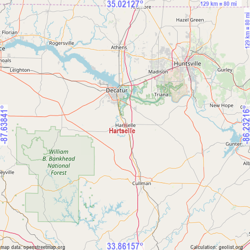
Hartselle GPS coordinates[2]
34° 26' 36.348" North, 86° 56' 7.008" West
| Map corner | latitude | longitude |
|---|---|---|
| Upper-left | 35.02127°, | -87.63841° |
| Center: | 34.44343°, | -86.93528° |
| Lower-right: | 33.86157°, | -86.23216° |
| Map W x H: | 128.9×128.9 km | = 80.1×80.1mi |
| max Lat: | 71.29058° ⇑77.9% North |
| Hartselle: | 34.44343° |
| min Lat: | ⇓22.1% South 19.06759° |
| min Long | Hartselle | max Long |
| -171.73463° | -86.93528° | -66.98998° |
| W 50.4%⇐ | ⇒49.6% E |
Elevation
Elevation of Hartselle is 203 m = 666 ft, and this is 91.8 m = 301 ft below average elevation for this country.
| Max E: |
3189 m = 10463 ft | 48.8% |
| Avg. | 294.8 m = 967 ft | |
| Hartselle | 203 m = 666 ft | |
Min E: |
-60 m = -197 ft | 51.2% |
See also: United States elevation on elevation.city.
Geographical zone
Hartselle is located in North temperate zone (between Tropic of Cancer and the Arctic Circle). Distance of this Northern Tropic circle is 1223.8 km =760.4 mi to South.| Distance of | km | miles | from Hartselle |
|---|---|---|---|
| North Pole | 6177.3 | 3838.4 | to North |
| Arctic Circle | 3571.4 | 2219.2 | to North |
| Tropic Cancer | 1223.8 | 760.4 | to South |
| Equator | 3829.8 | 2379.7 | to South |


Nearby cities:
15 places around Hartselle: (largest is in red/bold)
• Cullman
31 km =19.3 mi,  164°
164°
• Danville
14.3 km =8.9 mi,  257°
257°
• Decatur
18.6 km =11.6 mi,  346°
346°
• Eva
20.4 km =12.7 mi,  127°
127°
• Falkville
8.7 km =5.4 mi, 163°
• Flint City
9.4 km =5.8 mi,  340°
340°
• Hillsboro
32 km =19.9 mi,  312°
312°
• Madison
33.2 km =20.6 mi,  31°
31°
• Moulton
33.1 km =20.6 mi,  277°
277°
• Priceville
9.8 km =6.1 mi,  22°
22°
• Somerville
13 km =8.1 mi,  75°
75°
• South Vinemont
23.6 km =14.7 mi, 164°
• Triana
24.4 km =15.2 mi,  49°
49°
• Trinity
22.9 km =14.2 mi,  322°
322°
• West Point
22.9 km =14.2 mi,  185°
185°
Sources, notices
• [Note1] Compared only with cities in United States existing in our database
• [Src1] Map data: © OpenStreetMap contributors (CC-BY-SA)
• [Src2] Other city data from geonames.org with taken over terms of usage.
• [Src3] Geographical zone / Annual Mean Temperature by Robert A. Rohde @ Wikipedia
