Headland geodata
Headland (Alabama) is a populated place; located in United States in America/Chicago (GMT-5) time zone. With population of 4,736 people, there are 7405 cities with bigger population in this country. Compared to other cities in United States, 90% of cities are located further ↑North; 55% of cities are located further ←West and 66.4% of cities have higher elevation than Headland. Note1


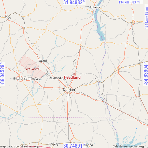
Headland GPS coordinates[2]
31° 21' 4.608" North, 85° 20' 31.776" West
| Map corner | latitude | longitude |
|---|---|---|
| Upper-left | 31.94982°, | -86.04529° |
| Center: | 31.35128°, | -85.34216° |
| Lower-right: | 30.74891°, | -84.63904° |
| Map W x H: | 133.5×133.5 km | = 83×83mi |
| max Lat: | 71.29058° ⇑90% North |
| Headland: | 31.35128° |
| min Lat: | ⇓10% South 19.06759° |
| min Long | Headland | max Long |
| -171.73463° | -85.34216° | -66.98998° |
| W 55%⇐ | ⇒45% E |
Elevation
Elevation of Headland is 121 m = 397 ft, and this is 173.8 m = 570 ft below average elevation for this country.
| Max E: |
3189 m = 10463 ft | 66.4% |
| Avg. | 294.8 m = 967 ft | |
| Headland | 121 m = 397 ft | |
Min E: |
-60 m = -197 ft | 33.6% |
See also: United States elevation on elevation.city.
Geographical zone
Headland is located in North temperate zone (between Tropic of Cancer and the Arctic Circle). Distance of this Northern Tropic circle is 880 km =546.8 mi to South.| Distance of | km | miles | from Headland |
|---|---|---|---|
| North Pole | 6521.1 | 4052 | to North |
| Arctic Circle | 3915.2 | 2432.8 | to North |
| Tropic Cancer | 880 | 546.8 | to South |
| Equator | 3485.9 | 2166 | to South |


Nearby cities:
15 places around Headland: (largest is in red/bold)
• Abbeville
26 km =16.2 mi,  19°
19°
• Ashford
21.2 km =13.2 mi,  151°
151°
• Avon
18.8 km =11.7 mi,  163°
163°
• Columbia
22.8 km =14.2 mi,  106°
106°
• Cowarts
17.2 km =10.7 mi,  168°
168°
• Dothan
15 km =9.3 mi,  197°
197°
• Grimes
11.3 km =7 mi,  242°
242°
• Kinsey
5.8 km =3.6 mi,  182°
182°
• Midland City
14.8 km =9.2 mi,  256°
256°
• Newton
25 km =15.5 mi,  265°
265°
• Newville
7.9 km =4.9 mi,  3°
3°
• Pinckard
20.5 km =12.7 mi, 257°
• Rehobeth
27.5 km =17.1 mi, 202°
• Taylor
23.9 km =14.9 mi,  210°
210°
• Webb
12 km =7.5 mi, 147°
Sources, notices
• [Note1] Compared only with cities in United States existing in our database
• [Src1] Map data: © OpenStreetMap contributors (CC-BY-SA)
• [Src2] Other city data from geonames.org with taken over terms of usage.
• [Src3] Geographical zone / Annual Mean Temperature by Robert A. Rohde @ Wikipedia
