Avon geodata
Avon (Alabama) is a populated place; located in United States in America/Chicago (GMT-5) time zone. With population of 530 people, there are 20501 cities with bigger population in this country. Compared to other cities in United States, 90.3% of cities are located further ↑North; 55.1% of cities are located further ←West and 73.9% of cities have higher elevation than Avon. Note1


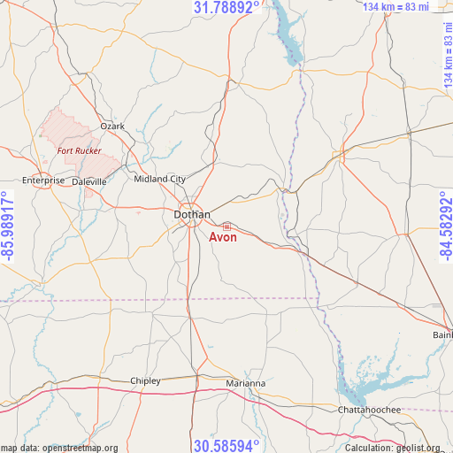
Avon GPS coordinates[2]
31° 11' 21.624" North, 85° 17' 9.744" West
| Map corner | latitude | longitude |
|---|---|---|
| Upper-left | 31.78892°, | -85.98917° |
| Center: | 31.18934°, | -85.28604° |
| Lower-right: | 30.58594°, | -84.58292° |
| Map W x H: | 133.8×133.8 km | = 83.1×83.1mi |
| max Lat: | 71.29058° ⇑90.3% North |
| Avon: | 31.18934° |
| min Lat: | ⇓9.7% South 19.06759° |
| min Long | Avon | max Long |
| -171.73463° | -85.28604° | -66.98998° |
| W 55.1%⇐ | ⇒44.9% E |
Elevation
Elevation of Avon is 78 m = 256 ft, and this is 216.8 m = 711 ft below average elevation for this country.
| Max E: |
3189 m = 10463 ft | 73.9% |
| Avg. | 294.8 m = 967 ft | |
| Avon | 78 m = 256 ft | |
Min E: |
-60 m = -197 ft | 26.1% |
See also: United States elevation on elevation.city.
Geographical zone
Avon is located in North temperate zone (between Tropic of Cancer and the Arctic Circle). Distance of this Northern Tropic circle is 862 km =535.6 mi to South.| Distance of | km | miles | from Avon |
|---|---|---|---|
| North Pole | 6539.1 | 4063.2 | to North |
| Arctic Circle | 3933.2 | 2444 | to North |
| Tropic Cancer | 862 | 535.6 | to South |
| Equator | 3467.9 | 2154.9 | to South |


Nearby cities:
15 places around Avon: (largest is in red/bold)
• Ashford
4.8 km =3 mi,  98°
98°
• Columbia
20.1 km =12.5 mi,  55°
55°
• Cottonwood
15.7 km =9.8 mi,  186°
186°
• Cowarts
2.1 km =1.3 mi,  304°
304°
• Dothan
10.6 km =6.6 mi,  290°
290°
• Grimes
20 km =12.4 mi,  309°
309°
• Headland
18.8 km =11.7 mi,  343°
343°
• Kinsey
13.4 km =8.3 mi, 335°
• Malone
28.3 km =17.6 mi,  155°
155°
• Malvern
22.9 km =14.2 mi,  255°
255°
• Midland City
24.5 km =15.2 mi, 306°
• Newville
26.3 km =16.3 mi,  349°
349°
• Rehobeth
17.5 km =10.9 mi,  245°
245°
• Taylor
17.5 km =10.9 mi, 261°
• Webb
8 km =5 mi,  8°
8°
Sources, notices
• [Note1] Compared only with cities in United States existing in our database
• [Src1] Map data: © OpenStreetMap contributors (CC-BY-SA)
• [Src2] Other city data from geonames.org with taken over terms of usage.
• [Src3] Geographical zone / Annual Mean Temperature by Robert A. Rohde @ Wikipedia
