Dothan geodata
Dothan (Alabama) is a seat of a second-order administrative division; located in United States in America/Chicago (GMT-5) time zone. With population of 68,567 people, there are 608 cities with bigger population in this country. Compared to other cities in United States, 90.2% of cities are located further ↑North; 54.9% of cities are located further ←West and 69.7% of cities have higher elevation than Dothan. Note1


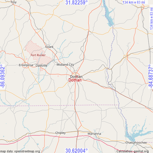
Dothan GPS coordinates[2]
31° 13' 23.628" North, 85° 23' 25.764" West
| Map corner | latitude | longitude |
|---|---|---|
| Upper-left | 31.82259°, | -86.09362° |
| Center: | 31.22323°, | -85.39049° |
| Lower-right: | 30.62004°, | -84.68737° |
| Map W x H: | 133.7×133.7 km | = 83.1×83.1mi |
| max Lat: | 71.29058° ⇑90.2% North |
| Dothan: | 31.22323° |
| min Lat: | ⇓9.8% South 19.06759° |
| min Long | Dothan | max Long |
| -171.73463° | -85.39049° | -66.98998° |
| W 54.9%⇐ | ⇒45.1% E |
Elevation
Elevation of Dothan is 102 m = 335 ft, and this is 192.8 m = 633 ft below average elevation for this country.
| Max E: |
3189 m = 10463 ft | 69.7% |
| Avg. | 294.8 m = 967 ft | |
| Dothan | 102 m = 335 ft | |
Min E: |
-60 m = -197 ft | 30.3% |
See also: Dothan elevation on elevation.city.
Geographical zone
Dothan is located in North temperate zone (between Tropic of Cancer and the Arctic Circle). Distance of this Northern Tropic circle is 865.8 km =538 mi to South.| Distance of | km | miles | from Dothan |
|---|---|---|---|
| North Pole | 6535.4 | 4060.9 | to North |
| Arctic Circle | 3929.5 | 2441.7 | to North |
| Tropic Cancer | 865.8 | 538 | to South |
| Equator | 3471.7 | 2157.2 | to South |


Nearby cities:
15 places around Dothan: (largest is in red/bold)
• Ashford
15.3 km =9.5 mi,  106°
106°
• Avon
10.6 km =6.6 mi, 110°
• Cottonwood
21 km =13 mi,  157°
157°
• Cowarts
8.6 km =5.3 mi, 107°
• Grimes
10.6 km =6.6 mi,  328°
328°
• Headland
15 km =9.3 mi,  17°
17°
• Kinsey
9.5 km =5.9 mi,  27°
27°
• Malvern
15.4 km =9.6 mi,  232°
232°
• Midland City
14.5 km =9 mi,  317°
317°
• Newville
22.6 km =14 mi,  12°
12°
• Pinckard
18.3 km =11.4 mi,  302°
302°
• Rehobeth
12.6 km =7.8 mi,  207°
207°
• Slocomb
23.2 km =14.4 mi,  236°
236°
• Taylor
9.8 km =6.1 mi, 228°
• Webb
11.9 km =7.4 mi,  69°
69°
Sources, notices
• [Note1] Compared only with cities in United States existing in our database
• [Src1] Map data: © OpenStreetMap contributors (CC-BY-SA)
• [Src2] Other city data from geonames.org with taken over terms of usage.
• [Src3] Geographical zone / Annual Mean Temperature by Robert A. Rohde @ Wikipedia
