Kimberly geodata
Kimberly (Alabama) is a populated place; located in United States in America/Chicago (GMT-5) time zone. With population of 2,892 people, there are 9818 cities with bigger population in this country. Compared to other cities in United States, 81.7% of cities are located further ↑North; 50.7% of cities are located further ←West and 63.1% of cities have higher elevation than Kimberly. Note1


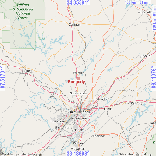
Kimberly GPS coordinates[2]
33° 46' 24.384" North, 86° 48' 49.968" West
| Map corner | latitude | longitude |
|---|---|---|
| Upper-left | 34.35591°, | -87.51701° |
| Center: | 33.77344°, | -86.81388° |
| Lower-right: | 33.18698°, | -86.11076° |
| Map W x H: | 130×130 km | = 80.8×80.8mi |
| max Lat: | 71.29058° ⇑81.7% North |
| Kimberly: | 33.77344° |
| min Lat: | ⇓18.3% South 19.06759° |
| min Long | Kimberly | max Long |
| -171.73463° | -86.81388° | -66.98998° |
| W 50.7%⇐ | ⇒49.3% E |
Elevation
Elevation of Kimberly is 138 m = 453 ft, and this is 156.8 m = 514 ft below average elevation for this country.
| Max E: |
3189 m = 10463 ft | 63.1% |
| Avg. | 294.8 m = 967 ft | |
| Kimberly | 138 m = 453 ft | |
Min E: |
-60 m = -197 ft | 36.9% |
See also: United States elevation on elevation.city.
Geographical zone
Kimberly is located in North temperate zone (between Tropic of Cancer and the Arctic Circle). Distance of this Northern Tropic circle is 1149.3 km =714.1 mi to South.| Distance of | km | miles | from Kimberly |
|---|---|---|---|
| North Pole | 6251.8 | 3884.7 | to North |
| Arctic Circle | 3645.9 | 2265.5 | to North |
| Tropic Cancer | 1149.3 | 714.1 | to South |
| Equator | 3755.3 | 2333.4 | to South |


Nearby cities:
15 places around Kimberly: (largest is in red/bold)
• Brookside
17.8 km =11.1 mi,  212°
212°
• Center Point
18.6 km =11.6 mi,  139°
139°
• Chalkville
20.4 km =12.7 mi,  131°
131°
• Clay
21.3 km =13.2 mi,  111°
111°
• Dixiana
15.6 km =9.7 mi,  103°
103°
• Fultondale
18.8 km =11.7 mi,  174°
174°
• Gardendale
12.6 km =7.8 mi,  179°
179°
• Gurley
16.3 km =10.1 mi,  88°
88°
• Hayden
14.2 km =8.8 mi,  21°
21°
• Morris
2.9 km =1.8 mi, 170°
• Mount Olive
12 km =7.5 mi,  198°
198°
• Pinson
15.3 km =9.5 mi, 127°
• Smoke Rise
13.2 km =8.2 mi,  357°
357°
• Trafford
8.2 km =5.1 mi,  52°
52°
• Warrior
4.6 km =2.9 mi,  5°
5°
Sources, notices
• [Note1] Compared only with cities in United States existing in our database
• [Src1] Map data: © OpenStreetMap contributors (CC-BY-SA)
• [Src2] Other city data from geonames.org with taken over terms of usage.
• [Src3] Geographical zone / Annual Mean Temperature by Robert A. Rohde @ Wikipedia
