Semmes geodata
Semmes (Alabama) is a populated place; located in United States in America/Chicago (GMT-5) time zone. With population of 3,886 people, there are 8348 cities with bigger population in this country. Compared to other cities in United States, 91.1% of cities are located further ↑North; 53.9% of cities are located further →East and 73.7% of cities have higher elevation than Semmes. Note1


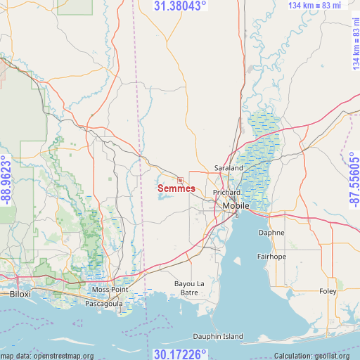
Semmes GPS coordinates[2]
30° 46' 41.664" North, 88° 15' 33.012" West
| Map corner | latitude | longitude |
|---|---|---|
| Upper-left | 31.38043°, | -88.9623° |
| Center: | 30.77824°, | -88.25917° |
| Lower-right: | 30.17226°, | -87.55605° |
| Map W x H: | 134.3×134.3 km | = 83.5×83.5mi |
| max Lat: | 71.29058° ⇑91.1% North |
| Semmes: | 30.77824° |
| min Lat: | ⇓8.9% South 19.06759° |
| min Long | Semmes | max Long |
| -171.73463° | -88.25917° | -66.98998° |
| W 46.1%⇐ | ⇒53.9% E |
Elevation
Elevation of Semmes is 79 m = 259 ft, and this is 215.8 m = 708 ft below average elevation for this country.
| Max E: |
3189 m = 10463 ft | 73.7% |
| Avg. | 294.8 m = 967 ft | |
| Semmes | 79 m = 259 ft | |
Min E: |
-60 m = -197 ft | 26.3% |
See also: United States elevation on elevation.city.
Geographical zone
Semmes is located in North temperate zone (between Tropic of Cancer and the Arctic Circle). Distance of this Northern Tropic circle is 816.3 km =507.2 mi to South.| Distance of | km | miles | from Semmes |
|---|---|---|---|
| North Pole | 6584.8 | 4091.6 | to North |
| Arctic Circle | 3979 | 2472.4 | to North |
| Tropic Cancer | 816.3 | 507.2 | to South |
| Equator | 3422.2 | 2126.5 | to South |


Nearby cities:
15 places around Semmes: (largest is in red/bold)
• Axis
27.8 km =17.3 mi,  52°
52°
• Big Point
30.1 km =18.7 mi,  225°
225°
• Chickasaw
17.7 km =11 mi,  95°
95°
• Creola
24.5 km =15.2 mi,  58°
58°
• Grand Bay
34.5 km =21.4 mi,  193°
193°
• Hurley
26 km =16.2 mi,  239°
239°
• Mobile
22.7 km =14.1 mi,  114°
114°
• Prichard
17.8 km =11.1 mi, 104°
• Saraland
18.6 km =11.6 mi,  75°
75°
• Satsuma
21.1 km =13.1 mi,  66°
66°
• Spanish Fort
34.8 km =21.6 mi, 109°
• Theodore
26.9 km =16.7 mi,  162°
162°
• Tillmans Corner
22.6 km =14 mi, 158°
• Wade
33.3 km =20.7 mi, 243°
• Wilmer
11 km =6.8 mi,  297°
297°
Sources, notices
• [Note1] Compared only with cities in United States existing in our database
• [Src1] Map data: © OpenStreetMap contributors (CC-BY-SA)
• [Src2] Other city data from geonames.org with taken over terms of usage.
• [Src3] Geographical zone / Annual Mean Temperature by Robert A. Rohde @ Wikipedia
