Satsuma geodata
Satsuma (Alabama) is a populated place; located in United States in America/Chicago (GMT-5) time zone. With population of 6,182 people, there are 6278 cities with bigger population in this country. Compared to other cities in United States, 91% of cities are located further ↑North; 53.1% of cities are located further →East and 95.7% of cities have higher elevation than Satsuma. Note1


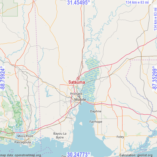
Satsuma GPS coordinates[2]
30° 51' 11.664" North, 88° 3' 21.996" West
| Map corner | latitude | longitude |
|---|---|---|
| Upper-left | 31.45495°, | -88.75924° |
| Center: | 30.85324°, | -88.05611° |
| Lower-right: | 30.24773°, | -87.35299° |
| Map W x H: | 134.2×134.2 km | = 83.4×83.4mi |
| max Lat: | 71.29058° ⇑91% North |
| Satsuma: | 30.85324° |
| min Lat: | ⇓9% South 19.06759° |
| min Long | Satsuma | max Long |
| -171.73463° | -88.05611° | -66.98998° |
| W 46.9%⇐ | ⇒53.1% E |
Elevation
Elevation of Satsuma is 8 m = 26 ft, and this is 286.8 m = 941 ft below average elevation for this country.
| Max E: |
3189 m = 10463 ft | 95.7% |
| Avg. | 294.8 m = 967 ft | |
| Satsuma | 8 m = 26 ft | |
Min E: |
-60 m = -197 ft | 4.3% |
See also: United States elevation on elevation.city.
Geographical zone
Satsuma is located in North temperate zone (between Tropic of Cancer and the Arctic Circle). Distance of this Northern Tropic circle is 824.6 km =512.4 mi to South.| Distance of | km | miles | from Satsuma |
|---|---|---|---|
| North Pole | 6576.5 | 4086.4 | to North |
| Arctic Circle | 3970.6 | 2467.2 | to North |
| Tropic Cancer | 824.6 | 512.4 | to South |
| Equator | 3430.6 | 2131.7 | to South |


Nearby cities:
15 places around Satsuma: (largest is in red/bold)
• Axis
9 km =5.6 mi,  17°
17°
• Bay Minette
27.2 km =16.9 mi,  83°
83°
• Chickasaw
10.1 km =6.3 mi,  190°
190°
• Citronelle
31.1 km =19.3 mi,  328°
328°
• Creola
4.6 km =2.9 mi, 20°
• Daphne
31.4 km =19.5 mi,  152°
152°
• Mobile
17.7 km =11 mi,  175°
175°
• Mount Vernon
26.1 km =16.2 mi,  8°
8°
• Prichard
12.9 km =8 mi, 189°
• Saraland
3.9 km =2.4 mi,  200°
200°
• Semmes
21.1 km =13.1 mi,  246°
246°
• Spanish Fort
24 km =14.9 mi, 145°
• Theodore
35.8 km =22.2 mi, 198°
• Tillmans Corner
31.2 km =19.4 mi, 200°
• Wilmer
29.3 km =18.2 mi,  263°
263°
Sources, notices
• [Note1] Compared only with cities in United States existing in our database
• [Src1] Map data: © OpenStreetMap contributors (CC-BY-SA)
• [Src2] Other city data from geonames.org with taken over terms of usage.
• [Src3] Geographical zone / Annual Mean Temperature by Robert A. Rohde @ Wikipedia
