Ozark geodata
Ozark (Alabama) is a seat of a second-order administrative division; located in United States in America/Chicago (GMT-5) time zone. With population of 14,719 people, there are 3291 cities with bigger population in this country. Compared to other cities in United States, 89.7% of cities are located further ↑North; 54.1% of cities are located further ←West and 64% of cities have higher elevation than Ozark. Note1


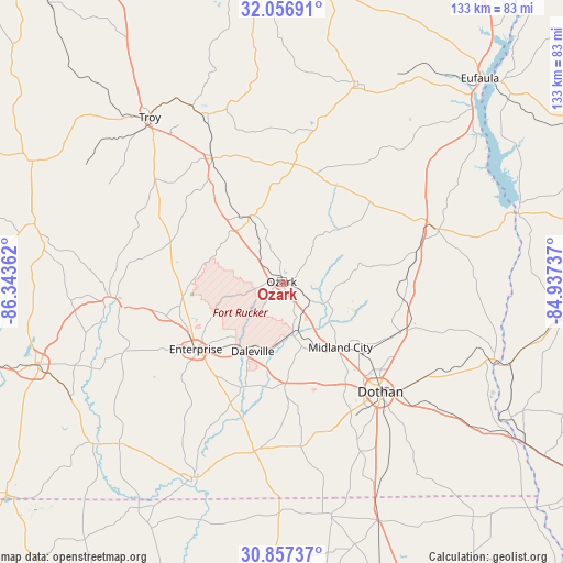
Ozark GPS coordinates[2]
31° 27' 32.616" North, 85° 38' 25.764" West
| Map corner | latitude | longitude |
|---|---|---|
| Upper-left | 32.05691°, | -86.34362° |
| Center: | 31.45906°, | -85.64049° |
| Lower-right: | 30.85737°, | -84.93737° |
| Map W x H: | 133.4×133.4 km | = 82.9×82.9mi |
| max Lat: | 71.29058° ⇑89.7% North |
| Ozark: | 31.45906° |
| min Lat: | ⇓10.3% South 19.06759° |
| min Long | Ozark | max Long |
| -171.73463° | -85.64049° | -66.98998° |
| W 54.1%⇐ | ⇒45.9% E |
Elevation
Elevation of Ozark is 133 m = 436 ft, and this is 161.8 m = 531 ft below average elevation for this country.
| Max E: |
3189 m = 10463 ft | 64% |
| Avg. | 294.8 m = 967 ft | |
| Ozark | 133 m = 436 ft | |
Min E: |
-60 m = -197 ft | 36% |
See also: United States elevation on elevation.city.
Geographical zone
Ozark is located in North temperate zone (between Tropic of Cancer and the Arctic Circle). Distance of this Northern Tropic circle is 892 km =554.3 mi to South.| Distance of | km | miles | from Ozark |
|---|---|---|---|
| North Pole | 6509.1 | 4044.6 | to North |
| Arctic Circle | 3903.3 | 2425.4 | to North |
| Tropic Cancer | 892 | 554.3 | to South |
| Equator | 3497.9 | 2173.5 | to South |


Nearby cities:
15 places around Ozark: (largest is in red/bold)
• Ariton
17.4 km =10.8 mi,  334°
334°
• Clayhatchee
26 km =16.2 mi,  197°
197°
• Clio
27.9 km =17.3 mi,  5°
5°
• Daleville
17.9 km =11.1 mi, 202°
• Enterprise
25.9 km =16.1 mi,  231°
231°
• Fort Rucker
14.8 km =9.2 mi,  208°
208°
• Grimes
25.1 km =15.6 mi,  133°
133°
• Headland
30.7 km =19.1 mi,  112°
112°
• Kinsey
33.3 km =20.7 mi,  122°
122°
• Level Plains
22 km =13.7 mi,  216°
216°
• Midland City
20.9 km =13 mi,  138°
138°
• New Brockton
28.6 km =17.8 mi,  253°
253°
• Newton
14.2 km =8.8 mi,  166°
166°
• Newville
29 km =18 mi,  98°
98°
• Pinckard
18.4 km =11.4 mi,  153°
153°
Sources, notices
• [Note1] Compared only with cities in United States existing in our database
• [Src1] Map data: © OpenStreetMap contributors (CC-BY-SA)
• [Src2] Other city data from geonames.org with taken over terms of usage.
• [Src3] Geographical zone / Annual Mean Temperature by Robert A. Rohde @ Wikipedia
