New Brockton geodata
New Brockton (Alabama) is a populated place; located in United States in America/Chicago (GMT-5) time zone. With population of 1,159 people, there are 15334 cities with bigger population in this country. Compared to other cities in United States, 89.9% of cities are located further ↑North; 53.1% of cities are located further ←West and 61.7% of cities have higher elevation than New Brockton. Note1


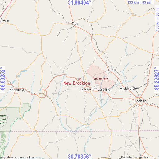
New Brockton GPS coordinates[2]
31° 23' 8.592" North, 85° 55' 45.804" West
| Map corner | latitude | longitude |
|---|---|---|
| Upper-left | 31.98404°, | -86.63252° |
| Center: | 31.38572°, | -85.92939° |
| Lower-right: | 30.78356°, | -85.22627° |
| Map W x H: | 133.5×133.5 km | = 83×83mi |
| max Lat: | 71.29058° ⇑89.9% North |
| New Brockton: | 31.38572° |
| min Lat: | ⇓10.1% South 19.06759° |
| min Long | New Brockton | max Long |
| -171.73463° | -85.92939° | -66.98998° |
| W 53.1%⇐ | ⇒46.9% E |
Elevation
Elevation of New Brockton is 146 m = 479 ft, and this is 148.8 m = 488 ft below average elevation for this country.
| Max E: |
3189 m = 10463 ft | 61.7% |
| Avg. | 294.8 m = 967 ft | |
| New Brockton | 146 m = 479 ft | |
Min E: |
-60 m = -197 ft | 38.3% |
See also: United States elevation on elevation.city.
Geographical zone
New Brockton is located in North temperate zone (between Tropic of Cancer and the Arctic Circle). Distance of this Northern Tropic circle is 883.8 km =549.2 mi to South.| Distance of | km | miles | from New Brockton |
|---|---|---|---|
| North Pole | 6517.3 | 4049.7 | to North |
| Arctic Circle | 3911.4 | 2430.4 | to North |
| Tropic Cancer | 883.8 | 549.2 | to South |
| Equator | 3489.8 | 2168.5 | to South |


Nearby cities:
15 places around New Brockton: (largest is in red/bold)
• Ariton
31.1 km =19.3 mi,  39°
39°
• Brantley
38 km =23.6 mi,  305°
305°
• Clayhatchee
25.8 km =16 mi,  130°
130°
• Daleville
22.2 km =13.8 mi,  112°
112°
• Elba
13.5 km =8.4 mi,  283°
283°
• Enterprise
10.5 km =6.5 mi,  138°
138°
• Fort Rucker
20.9 km =13 mi,  103°
103°
• Hartford
38.5 km =23.9 mi, 144°
• Kinston
29.7 km =18.5 mi,  230°
230°
• Level Plains
17.3 km =10.7 mi,  123°
123°
• Newton
31.3 km =19.4 mi, 100°
• Opp
33 km =20.5 mi,  249°
249°
• Ozark
28.6 km =17.8 mi,  73°
73°
• Pinckard
36.7 km =22.8 mi, 102°
• Samson
32.3 km =20.1 mi,  200°
200°
Sources, notices
• [Note1] Compared only with cities in United States existing in our database
• [Src1] Map data: © OpenStreetMap contributors (CC-BY-SA)
• [Src2] Other city data from geonames.org with taken over terms of usage.
• [Src3] Geographical zone / Annual Mean Temperature by Robert A. Rohde @ Wikipedia
