Bella Vista geodata
Bella Vista (Arkansas) is a populated place; located in United States in America/Chicago (GMT-5) time zone. With population of 27,999 people, there are 1785 cities with bigger population in this country. Compared to other cities in United States, 68.1% of cities are located further ↑North; 69.3% of cities are located further →East and 82% of cities have lower elevation than Bella Vista. Note1


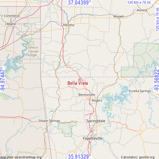
Bella Vista GPS coordinates[2]
36° 28' 50.52" North, 94° 16' 16.824" West
| Map corner | latitude | longitude |
|---|---|---|
| Upper-left | 37.04399°, | -94.97447° |
| Center: | 36.4807°, | -94.27134° |
| Lower-right: | 35.91329°, | -93.56822° |
| Map W x H: | 125.7×125.7 km | = 78.1×78.1mi |
| max Lat: | 71.29058° ⇑68.1% North |
| Bella Vista: | 36.4807° |
| min Lat: | ⇓31.9% South 19.06759° |
| min Long | Bella Vista | max Long |
| -171.73463° | -94.27134° | -66.98998° |
| W 30.7%⇐ | ⇒69.3% E |
Elevation
Elevation of Bella Vista is 376 m = 1234 ft, and this is 81.2 m = 266 ft above average elevation for this country.
| Max E: |
3189 m = 10463 ft | 18% |
| Bella Vista | 376 m 1234 ft | |
| Avg. | 294.8 m = 967 ft | |
Min E: |
-60 m = -197 ft | 82% |
See also: United States elevation on elevation.city.
Geographical zone
Bella Vista is located in North temperate zone (between Tropic of Cancer and the Arctic Circle). Distance of this Northern Tropic circle is 1450.4 km =901.2 mi to South.| Distance of | km | miles | from Bella Vista |
|---|---|---|---|
| North Pole | 5950.8 | 3697.7 | to North |
| Arctic Circle | 3344.9 | 2078.4 | to North |
| Tropic Cancer | 1450.4 | 901.2 | to South |
| Equator | 4056.3 | 2520.5 | to South |


Nearby cities:
15 places around Bella Vista: (largest is in red/bold)
• Anderson
24.4 km =15.2 mi,  320°
320°
• Avoca
20 km =12.4 mi,  115°
115°
• Bentonville
13.2 km =8.2 mi,  154°
154°
• Cave Springs
24.4 km =15.2 mi,  171°
171°
• Centerton
13.5 km =8.4 mi,  185°
185°
• Decatur
23.4 km =14.5 mi,  226°
226°
• Gravette
17.6 km =10.9 mi,  248°
248°
• Highfill
25.6 km =15.9 mi,  197°
197°
• Little Flock
16.1 km =10 mi,  130°
130°
• Noel
20.4 km =12.7 mi,  290°
290°
• Pea Ridge
14.3 km =8.9 mi,  102°
102°
• Pineville
16.2 km =10.1 mi, 321°
• Prairie Creek
24.3 km =15.1 mi, 129°
• Rogers
21.5 km =13.4 mi,  140°
140°
• Sulphur Springs
16.7 km =10.4 mi,  271°
271°
Sources, notices
• [Note1] Compared only with cities in United States existing in our database
• [Src1] Map data: © OpenStreetMap contributors (CC-BY-SA)
• [Src2] Other city data from geonames.org with taken over terms of usage.
• [Src3] Geographical zone / Annual Mean Temperature by Robert A. Rohde @ Wikipedia
