Bentonville geodata
Bentonville (Arkansas) is a seat of a second-order administrative division; located in United States in America/Chicago (GMT-5) time zone. With population of 44,499 people, there are 1070 cities with bigger population in this country. Compared to other cities in United States, 68.6% of cities are located further ↑North; 69.1% of cities are located further →East and 83.7% of cities have lower elevation than Bentonville. Note1


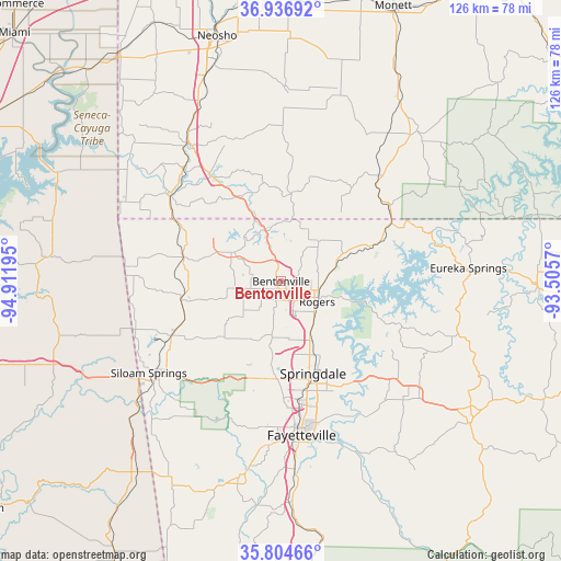
Bentonville GPS coordinates[2]
36° 22' 22.26" North, 94° 12' 31.752" West
| Map corner | latitude | longitude |
|---|---|---|
| Upper-left | 36.93692°, | -94.91195° |
| Center: | 36.37285°, | -94.20882° |
| Lower-right: | 35.80466°, | -93.5057° |
| Map W x H: | 125.9×125.9 km | = 78.2×78.2mi |
| max Lat: | 71.29058° ⇑68.6% North |
| Bentonville: | 36.37285° |
| min Lat: | ⇓31.4% South 19.06759° |
| min Long | Bentonville | max Long |
| -171.73463° | -94.20882° | -66.98998° |
| W 30.9%⇐ | ⇒69.1% E |
Elevation
Elevation of Bentonville is 400 m = 1312 ft, and this is 105.2 m = 345 ft above average elevation for this country.
| Max E: |
3189 m = 10463 ft | 16.3% |
| Bentonville | 400 m 1312 ft | |
| Avg. | 294.8 m = 967 ft | |
Min E: |
-60 m = -197 ft | 83.7% |
See also: Bentonville elevation on elevation.city.
Geographical zone
Bentonville is located in North temperate zone (between Tropic of Cancer and the Arctic Circle). Distance of this Northern Tropic circle is 1438.4 km =893.8 mi to South.| Distance of | km | miles | from Bentonville |
|---|---|---|---|
| North Pole | 5962.8 | 3705.1 | to North |
| Arctic Circle | 3356.9 | 2085.9 | to North |
| Tropic Cancer | 1438.4 | 893.8 | to South |
| Equator | 4044.3 | 2513 | to South |


Nearby cities:
15 places around Bentonville: (largest is in red/bold)
• Avoca
12.8 km =8 mi,  75°
75°
• Bella Vista
13.2 km =8.2 mi,  334°
334°
• Bethel Heights
19 km =11.8 mi,  158°
158°
• Cave Springs
12.3 km =7.6 mi,  189°
189°
• Centerton
7 km =4.3 mi,  258°
258°
• Elm Springs
18.7 km =11.6 mi, 187°
• Garfield
22.6 km =14 mi,  68°
68°
• Highfill
18.2 km =11.3 mi,  227°
227°
• Little Flock
6.7 km =4.2 mi, 77°
• Lowell
14.8 km =9.2 mi,  151°
151°
• Pea Ridge
12.3 km =7.6 mi,  42°
42°
• Prairie Creek
13.6 km =8.5 mi,  104°
104°
• Rogers
9.3 km =5.8 mi,  119°
119°
• Springdale
21.9 km =13.6 mi, 160°
• Tontitown
21.8 km =13.5 mi, 185°
Sources, notices
• [Note1] Compared only with cities in United States existing in our database
• [Src1] Map data: © OpenStreetMap contributors (CC-BY-SA)
• [Src2] Other city data from geonames.org with taken over terms of usage.
• [Src3] Geographical zone / Annual Mean Temperature by Robert A. Rohde @ Wikipedia
