Noel geodata
Noel (Missouri) is a populated place; located in United States in America/Chicago (GMT-5) time zone. With population of 1,824 people, there are 12461 cities with bigger population in this country. Compared to other cities in United States, 67.9% of cities are located further ↑North; 69.9% of cities are located further →East and 64.1% of cities have lower elevation than Noel. Note1
Administrative division(s):
- Level 1: Missouri
- Level 2: McDonald County
- Level 3: Township of Elk River East


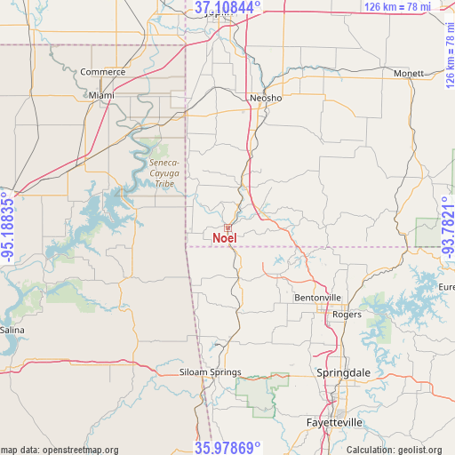
Noel GPS coordinates[2]
36° 32' 44.268" North, 94° 29' 6.792" West
| Map corner | latitude | longitude |
|---|---|---|
| Upper-left | 37.10844°, | -95.18835° |
| Center: | 36.54563°, | -94.48522° |
| Lower-right: | 35.97869°, | -93.7821° |
| Map W x H: | 125.6×125.6 km | = 78×78mi |
| max Lat: | 71.29058° ⇑67.9% North |
| Noel: | 36.54563° |
| min Lat: | ⇓32.1% South 19.06759° |
| min Long | Noel | max Long |
| -171.73463° | -94.48522° | -66.98998° |
| W 30.1%⇐ | ⇒69.9% E |
Elevation
Elevation of Noel is 258 m = 846 ft, and this is 36.8 m = 121 ft below average elevation for this country.
| Max E: |
3189 m = 10463 ft | 35.9% |
| Avg. | 294.8 m = 967 ft | |
| Noel | 258 m = 846 ft | |
Min E: |
-60 m = -197 ft | 64.1% |
See also: United States elevation on elevation.city.
Geographical zone
Noel is located in North temperate zone (between Tropic of Cancer and the Arctic Circle). Distance of this Northern Tropic circle is 1457.6 km =905.7 mi to South.| Distance of | km | miles | from Noel |
|---|---|---|---|
| North Pole | 5943.6 | 3693.2 | to North |
| Arctic Circle | 3337.7 | 2073.9 | to North |
| Tropic Cancer | 1457.6 | 905.7 | to South |
| Equator | 4063.5 | 2524.9 | to South |


Nearby cities:
15 places around Noel: (largest is in red/bold)
• Anderson
12.3 km =7.6 mi,  17°
17°
• Bella Vista
20.4 km =12.7 mi,  110°
110°
• Bentonville
31.3 km =19.4 mi,  127°
127°
• Centerton
27.3 km =17 mi,  139°
139°
• Copeland
33 km =20.5 mi,  291°
291°
• Decatur
23.4 km =14.5 mi,  174°
174°
• Gentry
30.9 km =19.2 mi,  179°
179°
• Goodman
23.1 km =14.4 mi, 19°
• Gravette
14 km =8.7 mi, 168°
• Grove
25.9 km =16.1 mi,  281°
281°
• Highfill
33.6 km =20.9 mi,  160°
160°
• Jay
31.1 km =19.3 mi,  243°
243°
• Pineville
10.5 km =6.5 mi,  58°
58°
• South West City
11.9 km =7.4 mi,  251°
251°
• Sulphur Springs
7.3 km =4.5 mi, 160°
Sources, notices
• [Note1] Compared only with cities in United States existing in our database
• [Src1] Map data: © OpenStreetMap contributors (CC-BY-SA)
• [Src2] Other city data from geonames.org with taken over terms of usage.
• [Src3] Geographical zone / Annual Mean Temperature by Robert A. Rohde @ Wikipedia
