Bryant geodata
Bryant (Arkansas) is a populated place; located in United States in America/Chicago (GMT-5) time zone. With population of 19,986 people, there are 2517 cities with bigger population in this country. Compared to other cities in United States, 77.3% of cities are located further ↑North; 65.2% of cities are located further →East and 65.2% of cities have higher elevation than Bryant. Note1


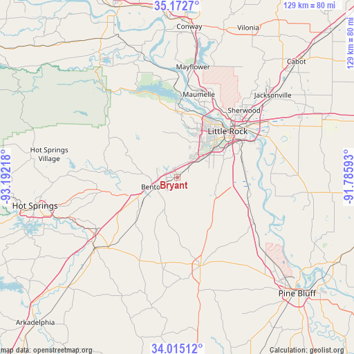
Bryant GPS coordinates[2]
34° 35' 45.348" North, 92° 29' 20.58" West
| Map corner | latitude | longitude |
|---|---|---|
| Upper-left | 35.1727°, | -93.19218° |
| Center: | 34.59593°, | -92.48905° |
| Lower-right: | 34.01512°, | -91.78593° |
| Map W x H: | 128.7×128.7 km | = 80×80mi |
| max Lat: | 71.29058° ⇑77.3% North |
| Bryant: | 34.59593° |
| min Lat: | ⇓22.7% South 19.06759° |
| min Long | Bryant | max Long |
| -171.73463° | -92.48905° | -66.98998° |
| W 34.8%⇐ | ⇒65.2% E |
Elevation
Elevation of Bryant is 127 m = 417 ft, and this is 167.8 m = 551 ft below average elevation for this country.
| Max E: |
3189 m = 10463 ft | 65.2% |
| Avg. | 294.8 m = 967 ft | |
| Bryant | 127 m = 417 ft | |
Min E: |
-60 m = -197 ft | 34.8% |
See also: United States elevation on elevation.city.
Geographical zone
Bryant is located in North temperate zone (between Tropic of Cancer and the Arctic Circle). Distance of this Northern Tropic circle is 1240.8 km =771 mi to South.| Distance of | km | miles | from Bryant |
|---|---|---|---|
| North Pole | 6160.4 | 3827.9 | to North |
| Arctic Circle | 3554.5 | 2208.7 | to North |
| Tropic Cancer | 1240.8 | 771 | to South |
| Equator | 3846.7 | 2390.2 | to South |


Nearby cities:
15 places around Bryant: (largest is in red/bold)
• Alexander
5.8 km =3.6 mi,  49°
49°
• Avilla
13 km =8.1 mi,  317°
317°
• Benton
9.6 km =6 mi,  248°
248°
• Cammack Village
24 km =14.9 mi,  32°
32°
• College Station
27.5 km =17.1 mi,  63°
63°
• East End
14.5 km =9 mi,  110°
110°
• Haskell
17.1 km =10.6 mi,  232°
232°
• Landmark
15.6 km =9.7 mi,  83°
83°
• Little Rock
24.8 km =15.4 mi, 47°
• North Little Rock
28 km =17.4 mi, 46°
• Salem
7.3 km =4.5 mi,  300°
300°
• Shannon Hills
9 km =5.6 mi,  72°
72°
• Sweet Home
24.7 km =15.3 mi, 65°
• Traskwood
22.2 km =13.8 mi,  222°
222°
• Wrightsville
24.9 km =15.5 mi,  88°
88°
Sources, notices
• [Note1] Compared only with cities in United States existing in our database
• [Src1] Map data: © OpenStreetMap contributors (CC-BY-SA)
• [Src2] Other city data from geonames.org with taken over terms of usage.
• [Src3] Geographical zone / Annual Mean Temperature by Robert A. Rohde @ Wikipedia
