Traskwood geodata
Traskwood (Arkansas) is a populated place; located in United States in America/Chicago (GMT-5) time zone. With population of 543 people, there are 20358 cities with bigger population in this country. Compared to other cities in United States, 77.9% of cities are located further ↑North; 65.5% of cities are located further →East and 70% of cities have higher elevation than Traskwood. Note1


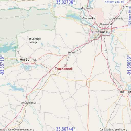
Traskwood GPS coordinates[2]
34° 26' 57.336" North, 92° 39' 14.58" West
| Map corner | latitude | longitude |
|---|---|---|
| Upper-left | 35.02706°, | -93.35718° |
| Center: | 34.44926°, | -92.65405° |
| Lower-right: | 33.86744°, | -91.95093° |
| Map W x H: | 128.9×128.9 km | = 80.1×80.1mi |
| max Lat: | 71.29058° ⇑77.9% North |
| Traskwood: | 34.44926° |
| min Lat: | ⇓22.1% South 19.06759° |
| min Long | Traskwood | max Long |
| -171.73463° | -92.65405° | -66.98998° |
| W 34.5%⇐ | ⇒65.5% E |
Elevation
Elevation of Traskwood is 101 m = 331 ft, and this is 193.8 m = 636 ft below average elevation for this country.
| Max E: |
3189 m = 10463 ft | 70% |
| Avg. | 294.8 m = 967 ft | |
| Traskwood | 101 m = 331 ft | |
Min E: |
-60 m = -197 ft | 30% |
See also: United States elevation on elevation.city.
Geographical zone
Traskwood is located in North temperate zone (between Tropic of Cancer and the Arctic Circle). Distance of this Northern Tropic circle is 1224.5 km =760.9 mi to South.| Distance of | km | miles | from Traskwood |
|---|---|---|---|
| North Pole | 6176.7 | 3838 | to North |
| Arctic Circle | 3570.8 | 2218.8 | to North |
| Tropic Cancer | 1224.5 | 760.9 | to South |
| Equator | 3830.4 | 2380.1 | to South |


Nearby cities:
15 places around Traskwood: (largest is in red/bold)
• Alexander
28 km =17.4 mi,  44°
44°
• Avilla
26.7 km =16.6 mi,  13°
13°
• Benton
14.2 km =8.8 mi,  25°
25°
• Bryant
22.2 km =13.8 mi, 42°
• East End
30.8 km =19.1 mi,  68°
68°
• Fountain Lake
33.5 km =20.8 mi,  294°
294°
• Haskell
6 km =3.7 mi,  15°
15°
• Hot Springs
37.3 km =23.2 mi,  279°
279°
• Landmark
35.5 km =22.1 mi,  59°
59°
• Leola
31.6 km =19.6 mi,  169°
169°
• Malvern
17.5 km =10.9 mi,  236°
236°
• Rockport
17.2 km =10.7 mi,  246°
246°
• Salem
21.8 km =13.5 mi, 23°
• Shannon Hills
30.4 km =18.9 mi,  51°
51°
• Sheridan
28.1 km =17.5 mi,  124°
124°
Sources, notices
• [Note1] Compared only with cities in United States existing in our database
• [Src1] Map data: © OpenStreetMap contributors (CC-BY-SA)
• [Src2] Other city data from geonames.org with taken over terms of usage.
• [Src3] Geographical zone / Annual Mean Temperature by Robert A. Rohde @ Wikipedia
