Benton geodata
Benton (Arkansas) is a seat of a second-order administrative division; located in United States in America/Chicago (GMT-5) time zone. With population of 34,177 people, there are 1441 cities with bigger population in this country. Compared to other cities in United States, 77.4% of cities are located further ↑North; 65.4% of cities are located further →East and 64.4% of cities have higher elevation than Benton. Note1


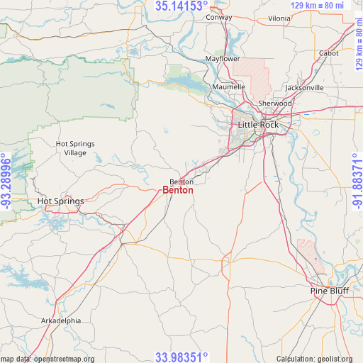
Benton GPS coordinates[2]
34° 33' 52.344" North, 92° 35' 12.588" West
| Map corner | latitude | longitude |
|---|---|---|
| Upper-left | 35.14153°, | -93.28996° |
| Center: | 34.56454°, | -92.58683° |
| Lower-right: | 33.98351°, | -91.88371° |
| Map W x H: | 128.8×128.8 km | = 80×80mi |
| max Lat: | 71.29058° ⇑77.4% North |
| Benton: | 34.56454° |
| min Lat: | ⇓22.6% South 19.06759° |
| min Long | Benton | max Long |
| -171.73463° | -92.58683° | -66.98998° |
| W 34.6%⇐ | ⇒65.4% E |
Elevation
Elevation of Benton is 131 m = 430 ft, and this is 163.8 m = 537 ft below average elevation for this country.
| Max E: |
3189 m = 10463 ft | 64.4% |
| Avg. | 294.8 m = 967 ft | |
| Benton | 131 m = 430 ft | |
Min E: |
-60 m = -197 ft | 35.6% |
See also: United States elevation on elevation.city.
Geographical zone
Benton is located in North temperate zone (between Tropic of Cancer and the Arctic Circle). Distance of this Northern Tropic circle is 1237.3 km =768.8 mi to South.| Distance of | km | miles | from Benton |
|---|---|---|---|
| North Pole | 6163.8 | 3830 | to North |
| Arctic Circle | 3558 | 2210.8 | to North |
| Tropic Cancer | 1237.3 | 768.8 | to South |
| Equator | 3843.2 | 2388.1 | to South |


Nearby cities:
15 places around Benton: (largest is in red/bold)
• Alexander
15.2 km =9.4 mi,  61°
61°
• Avilla
13.1 km =8.1 mi,  0°
0°
• Bryant
9.6 km =6 mi,  68°
68°
• Cammack Village
32.2 km =20 mi,  42°
42°
• East End
22.6 km =14 mi,  93°
93°
• Haskell
8.4 km =5.2 mi,  213°
213°
• Landmark
25 km =15.5 mi,  78°
78°
• Little Rock
33.9 km =21.1 mi,  53°
53°
• Malvern
30.6 km =19 mi,  222°
222°
• Rockport
29.4 km =18.3 mi,  228°
228°
• Salem
7.6 km =4.7 mi,  20°
20°
• Shannon Hills
18.6 km =11.6 mi, 70°
• Sheridan
33.3 km =20.7 mi,  149°
149°
• Traskwood
14.2 km =8.8 mi, 205°
• Wrightsville
34.1 km =21.2 mi, 82°
Sources, notices
• [Note1] Compared only with cities in United States existing in our database
• [Src1] Map data: © OpenStreetMap contributors (CC-BY-SA)
• [Src2] Other city data from geonames.org with taken over terms of usage.
• [Src3] Geographical zone / Annual Mean Temperature by Robert A. Rohde @ Wikipedia
