College City geodata
College City (Arkansas) is a populated place; located in United States in America/Chicago (GMT-5) time zone. With population of 537 people, there are 20425 cities with bigger population in this country. Compared to other cities in United States, 69.8% of cities are located further ↑North; 61.9% of cities are located further →East and 72.7% of cities have higher elevation than College City. Note1
Administrative division(s):
- Level 1: Arkansas
- Level 2: Lawrence County
- Level 3: Township of Campbell


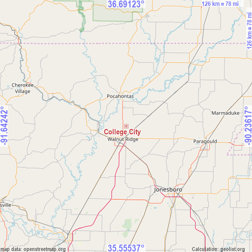
College City GPS coordinates[2]
36° 7' 31.26" North, 90° 56' 21.444" West
| Map corner | latitude | longitude |
|---|---|---|
| Upper-left | 36.69123°, | -91.64242° |
| Center: | 36.12535°, | -90.93929° |
| Lower-right: | 35.55537°, | -90.23617° |
| Map W x H: | 126.3×126.3 km | = 78.5×78.5mi |
| max Lat: | 71.29058° ⇑69.8% North |
| College City: | 36.12535° |
| min Lat: | ⇓30.2% South 19.06759° |
| min Long | College City | max Long |
| -171.73463° | -90.93929° | -66.98998° |
| W 38.1%⇐ | ⇒61.9% E |
Elevation
Elevation of College City is 85 m = 279 ft, and this is 209.8 m = 688 ft below average elevation for this country.
| Max E: |
3189 m = 10463 ft | 72.7% |
| Avg. | 294.8 m = 967 ft | |
| College City | 85 m = 279 ft | |
Min E: |
-60 m = -197 ft | 27.3% |
See also: United States elevation on elevation.city.
Geographical zone
College City is located in North temperate zone (between Tropic of Cancer and the Arctic Circle). Distance of this Northern Tropic circle is 1410.8 km =876.6 mi to South.| Distance of | km | miles | from College City |
|---|---|---|---|
| North Pole | 5990.3 | 3722.2 | to North |
| Arctic Circle | 3384.4 | 2103 | to North |
| Tropic Cancer | 1410.8 | 876.6 | to South |
| Equator | 4016.8 | 2495.9 | to South |


Nearby cities:
15 places around College City: (largest is in red/bold)
• Black Rock
14.3 km =8.9 mi,  262°
262°
• Bono
27 km =16.8 mi,  152°
152°
• Brookland
40.7 km =25.3 mi,  127°
127°
• Corning
45 km =28 mi,  45°
45°
• Hardy
53.1 km =33 mi,  293°
293°
• Hoxie
8.9 km =5.5 mi,  201°
201°
• Imboden
22.8 km =14.2 mi, 292°
• Jonesboro
37.9 km =23.5 mi, 146°
• Marmaduke
50.4 km =31.3 mi,  82°
82°
• Oak Grove Heights
38.5 km =23.9 mi,  90°
90°
• Paragould
40.4 km =25.1 mi,  100°
100°
• Pocahontas
15.4 km =9.6 mi,  349°
349°
• Swifton
37.8 km =23.5 mi,  206°
206°
• Tuckerman
49.7 km =30.9 mi, 207°
• Walnut Ridge
6.5 km =4 mi,  193°
193°
Sources, notices
• [Note1] Compared only with cities in United States existing in our database
• [Src1] Map data: © OpenStreetMap contributors (CC-BY-SA)
• [Src2] Other city data from geonames.org with taken over terms of usage.
• [Src3] Geographical zone / Annual Mean Temperature by Robert A. Rohde @ Wikipedia
