Hoxie geodata
Hoxie (Arkansas) is a populated place; located in United States in America/Chicago (GMT-5) time zone. With population of 2,680 people, there are 10216 cities with bigger population in this country. Compared to other cities in United States, 70.2% of cities are located further ↑North; 62% of cities are located further →East and 73.7% of cities have higher elevation than Hoxie. Note1


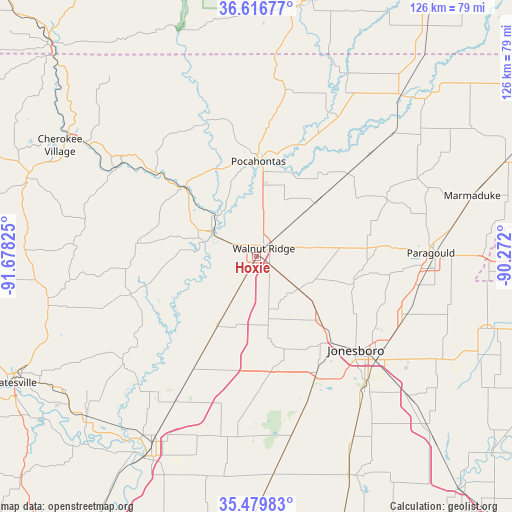
Hoxie GPS coordinates[2]
36° 3' 1.26" North, 90° 58' 30.432" West
| Map corner | latitude | longitude |
|---|---|---|
| Upper-left | 36.61677°, | -91.67825° |
| Center: | 36.05035°, | -90.97512° |
| Lower-right: | 35.47983°, | -90.272° |
| Map W x H: | 126.4×126.4 km | = 78.5×78.5mi |
| max Lat: | 71.29058° ⇑70.2% North |
| Hoxie: | 36.05035° |
| min Lat: | ⇓29.8% South 19.06759° |
| min Long | Hoxie | max Long |
| -171.73463° | -90.97512° | -66.98998° |
| W 38%⇐ | ⇒62% E |
Elevation
Elevation of Hoxie is 79 m = 259 ft, and this is 215.8 m = 708 ft below average elevation for this country.
| Max E: |
3189 m = 10463 ft | 73.7% |
| Avg. | 294.8 m = 967 ft | |
| Hoxie | 79 m = 259 ft | |
Min E: |
-60 m = -197 ft | 26.3% |
See also: United States elevation on elevation.city.
Geographical zone
Hoxie is located in North temperate zone (between Tropic of Cancer and the Arctic Circle). Distance of this Northern Tropic circle is 1402.5 km =871.5 mi to South.| Distance of | km | miles | from Hoxie |
|---|---|---|---|
| North Pole | 5998.6 | 3727.4 | to North |
| Arctic Circle | 3392.8 | 2108.2 | to North |
| Tropic Cancer | 1402.5 | 871.5 | to South |
| Equator | 4008.4 | 2490.7 | to South |


Nearby cities:
15 places around Hoxie: (largest is in red/bold)
• Bay
50.6 km =31.4 mi,  132°
132°
• Black Rock
12.7 km =7.9 mi,  300°
300°
• Bono
22.1 km =13.7 mi,  135°
135°
• Brookland
39.1 km =24.3 mi,  115°
115°
• College City
8.9 km =5.5 mi,  21°
21°
• Diaz
52.7 km =32.7 mi,  209°
209°
• Imboden
24.6 km =15.3 mi,  313°
313°
• Jonesboro
33.6 km =20.9 mi, 133°
• Oak Grove Heights
42.5 km =26.4 mi,  79°
79°
• Paragould
43 km =26.7 mi,  88°
88°
• Pocahontas
23.5 km =14.6 mi,  0°
0°
• Swifton
28.9 km =18 mi, 208°
• Tuckerman
40.8 km =25.4 mi, 209°
• Walnut Ridge
2.6 km =1.6 mi,  40°
40°
• Weiner
48.3 km =30 mi,  171°
171°
Sources, notices
• [Note1] Compared only with cities in United States existing in our database
• [Src1] Map data: © OpenStreetMap contributors (CC-BY-SA)
• [Src2] Other city data from geonames.org with taken over terms of usage.
• [Src3] Geographical zone / Annual Mean Temperature by Robert A. Rohde @ Wikipedia
