Humphrey geodata
Humphrey (Arkansas) is a populated place; located in United States in America/Chicago (GMT-5) time zone. With population of 524 people, there are 20579 cities with bigger population in this country. Compared to other cities in United States, 78% of cities are located further ↑North; 63.5% of cities are located further →East and 77.1% of cities have higher elevation than Humphrey. Note1


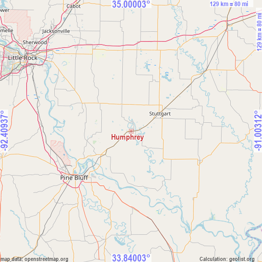
Humphrey GPS coordinates[2]
34° 25' 19.344" North, 91° 42' 22.464" West
| Map corner | latitude | longitude |
|---|---|---|
| Upper-left | 35.00003°, | -92.40937° |
| Center: | 34.42204°, | -91.70624° |
| Lower-right: | 33.84003°, | -91.00312° |
| Map W x H: | 129×129 km | = 80.2×80.2mi |
| max Lat: | 71.29058° ⇑78% North |
| Humphrey: | 34.42204° |
| min Lat: | ⇓22% South 19.06759° |
| min Long | Humphrey | max Long |
| -171.73463° | -91.70624° | -66.98998° |
| W 36.5%⇐ | ⇒63.5% E |
Elevation
Elevation of Humphrey is 60 m = 197 ft, and this is 234.8 m = 770 ft below average elevation for this country.
| Max E: |
3189 m = 10463 ft | 77.1% |
| Avg. | 294.8 m = 967 ft | |
| Humphrey | 60 m = 197 ft | |
Min E: |
-60 m = -197 ft | 22.9% |
See also: United States elevation on elevation.city.
Geographical zone
Humphrey is located in North temperate zone (between Tropic of Cancer and the Arctic Circle). Distance of this Northern Tropic circle is 1221.5 km =759 mi to South.| Distance of | km | miles | from Humphrey |
|---|---|---|---|
| North Pole | 6179.7 | 3839.9 | to North |
| Arctic Circle | 3573.8 | 2220.7 | to North |
| Tropic Cancer | 1221.5 | 759 | to South |
| Equator | 3827.4 | 2378.2 | to South |


Nearby cities:
15 places around Humphrey: (largest is in red/bold)
• Altheimer
17.3 km =10.7 mi,  228°
228°
• Carlisle
40.3 km =25 mi,  354°
354°
• Clarendon
46.9 km =29.1 mi,  50°
50°
• De Valls Bluff
46.3 km =28.8 mi,  29°
29°
• De Witt
36.7 km =22.8 mi,  113°
113°
• England
27.7 km =17.2 mi,  299°
299°
• Gillett
45.5 km =28.3 mi,  138°
138°
• Hazen
41.5 km =25.8 mi,  16°
16°
• Holly Grove
50.3 km =31.3 mi,  67°
67°
• Lonoke
44 km =27.3 mi,  336°
336°
• Pine Bluff
34.7 km =21.6 mi, 231°
• Redfield
43.8 km =27.2 mi,  273°
273°
• Stuttgart
16.6 km =10.3 mi,  58°
58°
• Sulphur Springs
46.8 km =29.1 mi, 234°
• White Hall
39 km =24.2 mi,  245°
245°
Sources, notices
• [Note1] Compared only with cities in United States existing in our database
• [Src1] Map data: © OpenStreetMap contributors (CC-BY-SA)
• [Src2] Other city data from geonames.org with taken over terms of usage.
• [Src3] Geographical zone / Annual Mean Temperature by Robert A. Rohde @ Wikipedia
